 Route Editor

| Guide | ♦ | 3 Triplogs | 0 Topics |
details | drive | permit | forecast | route |
stats |
photos | triplogs | topics | location |
| 80 | 3 | 0 |
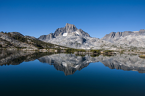
The second hardest route by slegal The High Trail officially starts at Agnew Meadows. From the trailhead, the trail heads up a series of switchbacks for about 400 vertical feet and continues to climb in a northwesterly direction once the switchbacks end until the trail tops out at about 9,700 feet. There are many small stream crossings during the first half of the hike and abundant wildflowers. There was lots of wild onion at all of the stream crossings when I hiked the trail. This stuff is quite tasty.
From Badger Lakes the trail climbs steeply toward the high point of the trail to about 9,850. Along the way, the middle fork of the San Joaquin River is adjacent to the trail. Soon, the trail reaches a number of small linked ponds that are part of the outflow of Thousand Island Lake. This is where the Middle Fork of the San Joaquin River is still just a small stream. Here, Banner Peak is constantly in view due west. At the high point of the trail you are greeted with your first view of Thousand Island Lake. The trail is fairly flat from this point all of the way to Thousand Island Lake. After approximately, 8.7 miles, the High Trail and The John Muir Trail intersect adjacent to Thousand Island Lake. This is quite a gathering place for hikers, but camping is not allowed near the outlet of the lake. Numerous campsite exist on both sides of the lake beyond about a quarter mile from the outlet. Check out the Official Route and Triplogs. Note This is a moderately difficult hike. Leave No Trace and +Add a Triplog after your hike to support this local community. One-Way Notice This hike is listed as One-Way. When hiking several trails on a single "hike", log it with a generic name that describes the hike. Then link the trails traveled, check out the example. | ||||||||||||||||||||||||||||||||||||||||||||||||||||||||||||||||||||||||||||||||||||||||||||||||


