Route Editor

| Guide | ♦ | 11 Triplogs | 0 Topics |
details | drive | no permit | forecast | route |
stats |
photos | triplogs | topics | location |
| 13 | 11 | 0 |
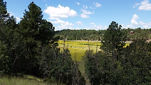
tour de Show Low Bluff by cw50must   A 1.5-mile loop in the center of town. It is an easy trail located right off of White Mountain BLVD (HWY 260). Signs from both directions let you know the trailhead location. The trailhead has a nice little parking lot. From there you follow a path with a bridge over the Show Low Creek to the trail. A 1.5-mile loop in the center of town. It is an easy trail located right off of White Mountain BLVD (HWY 260). Signs from both directions let you know the trailhead location. The trailhead has a nice little parking lot. From there you follow a path with a bridge over the Show Low Creek to the trail.The trail is a loop, the bottom half follows along the base of the bluff. Then as it loops back you make your way up onto the bluff and eventually back down to where you started. There is even a short spur to a lookout. The trail is in the pines and provides nice views of Show Low, Show Low Creek, and a nice meadow. Which will contain some nice wildflowers and/or cows. There is also a Frisbee Golf course (frolf) tossed into the mix here. Well maintained, and has some benches for pondering.
Check out the Official Route and Triplogs. Leave No Trace and +Add a Triplog after your hike to support this local community. | |||||||||||||||||||||||||||||||||||||||||||||||||||||||||||||||||||||||||||||||||||||