Route Editor

| Guide | ♦ | 3 Triplogs | 0 Topics |
details | drive | permit | forecast | route |
stats |
photos | triplogs | topics | location |
| 10 | 3 | 0 |
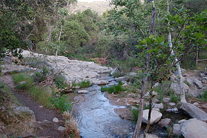
AgentP of Nature by AndreyP It goes up a little and then descends providing views of Decker and Long canyons until it reaches the bottom of Long Canyon. There is a seasonal creek here during spring months that is downstream from Ortega Falls.
Upper San Juan campground can be accessed from the trail. The loop trail ends at the south side of the parking lot near a vault toilet. Cleveland FS Details Start playing the Agents of Nature mobile game as soon as you arrive to the San Juan Loop Trail. This game will get kids moving and learning about nature, culture, science, and technology in a unique, enjoyable way. For more information, please visit www.agentsofnature.com Check out the Official Route and Triplogs. Leave No Trace and +Add a Triplog after your hike to support this local community. | ||||||||||||||||||||||||||||||||||||||||||||||||||||||||||||||||||||||||||||||||||