 Route Editor

| Guide | ♦ | 2 Triplogs | 0 Topics |
details | drive | permit | forecast | route |
stats |
photos | triplogs | topics | location |
| 17 | 2 | 0 |
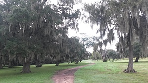
If you like gators... by SunDevil3 There are three short spurs off the main trail that link to other features/trails within Brazos Bend but the main loop comes in at 1.7 miles and the trail hugs the shoreline of Elm Lake for its duration. Heading east from the parking area and observation deck, the trail follows around the contours of the lake as it turns South and then West along the Southern edge of the lake. The shoreline here is dotted with about seven small "piers" for viewing wildlife and/or fishing.
Elm Lake Trail continues on to the West before turning North a short distance later to follow the lakeshore. At this point, the 1.2 mile-long 40-Acre Lake Trail continues on to the West to access the observation tower and 40-Acre Lake. Continuing North on Elm Lake Trail will eventually lead you to one last spur, Horseshoe Lake Loop Trail, leading to the Northwest just before returning to the main parking area.
Check out the Official Route and Triplogs. Leave No Trace and +Add a Triplog after your hike to support this local community. One-Way Notice This hike is listed as One-Way. When hiking several trails on a single "hike", log it with a generic name that describes the hike. Then link the trails traveled, check out the example. | |||||||||||||||||||||||||||||||||||||||||||||||||||||||||||||||||||||||||||||||||||||||||


