Route Editor

| Guide | ♦ | 13 Triplogs | 0 Topics |
details | drive | no permit | forecast | 🔥 route |
stats |
photos | triplogs | topics | location |
| 82 | 13 | 0 |
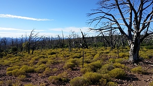
it's a gem by charlieaz   My primary objective for this hike was to reach Little Diamond Rim's highest point to participate in Summits on the Air (SOTA). It turned out to be an enjoyable hike with interesting landscapes. I didn’t hike to the edge once on top and check out the view because of time constraints. The high point is nothing to write home about, but it was my destination for SOTA. My primary objective for this hike was to reach Little Diamond Rim's highest point to participate in Summits on the Air (SOTA). It turned out to be an enjoyable hike with interesting landscapes. I didn’t hike to the edge once on top and check out the view because of time constraints. The high point is nothing to write home about, but it was my destination for SOTA.From Mesa, I took the Beeline Hwy 87 to Payson. I proceeded north past Payson and turned right on to Houston Mesa Road (NF-199). From there, I drove to the Whispering Pine hamlet. I parked off Houston Mesa across from where Scott Drive intersects with it. My map shows it to be at the mouth of Bear Canyon. It appears the Forest Service is repairing or improving the road up Bear Canyon because the road was coned off, indicating no vehicle access, and it was graded recently.
This hike is nearly flat with a couple of steep sections that will get your heart rate up. The most vertical is the section just after passing through the gate and heading up the hill on the ATV road. At this point, I was still in ponderosa pine, but as I progressed, the pine thinned out, and juniper became the norm. And then, surprise! The last third of the hike is a barren wasteland of charred sticks from a forest fire. I left the fence line for the last 0.3 miles and traveled off-trail to the summit. This hike has a lot of exposure. I would not recommend doing it in mid-summer. But in my opinion, it was an easy hike. It is 2.7 miles each way. I arrived at the top in 1 hour and 30 minutes, and it only took me 50 minutes to go down from the high point to my car. Gate Policy: If a gate is closed upon arrival, leave it closed after you go through. If it is open, leave it open. Leaving a closed gate open may put cattle in danger. Closing an open gate may cut them off from water. Please be respectful, leave gates as found. The exception is signage on the gate directing you otherwise. Check out the Official Route and Triplogs. Leave No Trace and +Add a Triplog after your hike to support this local community. | |||||||||||||||||||||||||||||||||||||||||||||||||||||||||||||||||||||||||||||||||||||||||||