Lean-To Canyon, UT • Hike
 

Lean-To Canyon, UT

Guide 1 Triplog Mine 0 0 Topics
 
2.5 of 5 
Fav
Wish
0
details
drive
no permit
forecast
route  
stats
photos
triplog
topics
location
0 1 0
Statistics
tap icons for details
Difficulty 3.5 of 5
Route Finding 5 of 5
Distance One Way 11.37 miles
Trailhead Elevation 6,838 feet
Elevation Gain -2,762 feet
Accumulated Gain 1,210 feet
Kokopelli Seeds 15.4
 Interest Off-Trail Hiking & Perennial Creek
 Dogs not allowed
feature photo
Photos Viewed All MineFollowing
21  2015-09-05
Sundance Trail to Dark Canyon
nonot
Author
author avatar Guides 16,881
Routes 17,283
Photos 24
Trips 1 map ( 6 miles )
Age 26 Male Gender
Location HAZ, TrailDEX
Associated Areas
list map done
Southeast Region
Historical Weather
Trailhead Forecast
Radar Map
Expand Map
Preferred May, Oct, Sep, Apr
Sun  6:51am - 6:15pm
Official Route
 
1 Alternative
 
 Water
Nearby Area Water
[ View More! ]
no photo labels yet
+Add > Photos to this Guide
then label as applicable

Guide Needed
Publish Full Detail Guide


Use +Add above to share photos and triplogs
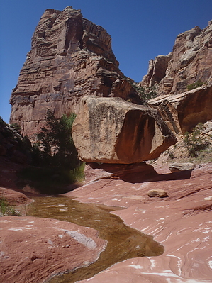
A descent down Lean-To Canyon requires careful navigation, downclimbing, bypasses, wading and ends with a nice hike on a trail around the huge dryfall. This is a difficult trip only for people with significant outdoors experience.

Check out the Official Route and Triplog.


Leave No Trace and +Add a Triplog after your hike to support this local community.

2015-09-20

    One-Way Notice
    This hike is listed as One-Way.

    When hiking several trails on a single "hike", log it with a generic name that describes the hike. Then link the trails traveled, check out the example.
    WARNING! Hiking and outdoor related sports can be dangerous. Be responsible and prepare for the trip. Study the area you are entering and plan accordingly. Dress for the current and unexpected weather changes. Take plenty of water. Never go alone. Make an itinerary with your plan(s), route(s), destination(s) and expected return time. Give your itinerary to trusted family and/or friends.

     Permit $$
    None


     Directions
    or
    or
     Road
    FR / Jeep Road - Car possible when dry

    To hike
    Your goal is to get to Sweet Alice Road. This is a VERY remote place.

    From Mexican Hat, drive north on highway 261, up the Moki Dugway (no trailers or RVs allowed), go west on highway 95, then north after a few miles onto 275 (towards Natural Bridges state park.) Use the Elk Ridge access road, turning left at the junction with FR268, until you reach sweet alice road, then turn left onto Sweet Alice road. Bring a GPS and a map.
    page created by nonot on Sep 20 2015 1:49 pm
    helpcorrectionissue

    end of page marker