Route Editor

| Guide | ♦ | 306 Triplogs | 26 Topics |
details | drive | permit | forecast | route |
stats |
photos | triplogs | topics | location |
| 5.3k | 306 | 26 |
Canyons are inherently risky. Flash floods occur without notice on sunny days. Technical skills & surrounding topography knowledge required yet does not eliminate risk.
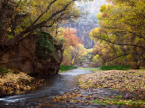
Arizona Heaven! by Kip   Forget about doing this hike with a specific destination in mind. Instead, dedicate your trip to playing in the water, relaxing by the bank, and, if you like boulder hopping, to exploring a side canyon. Forget about doing this hike with a specific destination in mind. Instead, dedicate your trip to playing in the water, relaxing by the bank, and, if you like boulder hopping, to exploring a side canyon.With that said, if you are in good shape and backpacking this trail for the first time, try hiking to Horse Camp Canyon on day one, exploring Horse Camp Canyon, and playing in the water on day two, and then just relaxing and heading home on day three.
There are several footpaths on both sides of the creek. These are not maintained trails. So depending on the water level and vegetation growth, they may or may not be there throughout the year. As a general rule, when one side of the canyon is a sheer rock wall, and the other side is a flat patch of land, the footpath is on the flat-patch-of-land side. If both sides are sheer rock wall, hike through the water. For a backpacking trip, I recommend using boots (not your favorite pair because of water damage) for both the hike and for exploring the side canyons. Bring a pair of sandals for the campsite so you can dry off your boots and feet. If you want to do the hike in sandals, consider bringing a hiking pole for extra support or just picking up a tree branch/walking stick along the way. The rocks in the creek are slick, so be prepared to slip and stumble. As for navigation, I suggest a GPS and the mileage chart available on the BLM (Bureau of Land Management) web site. Compare the miles you have traveled on your GPS to the mileage chart. GPS gives you a general idea of where you are. Forget about trying to check each canyon off on your map as you pass it. Most of the canyons are covered with trees and boulders and are hard to spot. I found two landmarks helpful, Virgus Canyon and the dirt hills around the west entrance: When hiking into the canyon from the west entrance, Virgus Canyon is pretty easy to spot. If you've been walking for a while (4.5 miles) and the top of the south canyon wall makes it look like the creek is going to fork, you are most likely approaching Virgus. When hiking out of the canyon on the west side, there is a point where you exit the rock canyon walls and are surrounded by desert hills. You now have about a mile to go. Make sure to keep an eye out on the north side of the creek for the trail back up to the parking lot. I worried about having to swim with my camera, but I never ran into any deep water that I couldn't walk around. Water levels can vary significantly from time to time. On this trip, at least, the average depth was about a foot deep, and in early April, the water temperature was very comfortable. I had to wade through several knee-deep areas, but I never had to swim. There are sweet camping spots across from the entrance to Horse Camp Canyon. On the south side of the canyon, go 60 to 100 yards west of the canyon entrance and walk to the back. Hopefully, you'll run into a campsite with a fire pit, plenty of trees for hanging food and packs, and plenty of level cleared ground for stoves and tents. Of the two canyons I explored, I found Horse Camp much more accessible and exciting than Booger. Horse Camp requires boulder hopping, pulling yourself up in some areas, and scrambling through thorny stuff. Using some footpaths on the east side of the canyon, I tried to make it up to the caves. I got as far as the large pool, but I couldn't find a way to pull myself up while waste-deep in water. Going up on the west side might be better. If you get up above the canyon walls, please be careful. Only loose rocks and dead plants are there to help you if you slip. If you plan on exploring a side canyon, bring a day pack and plenty of water. Once you leave the shade by the creek, you might as well be in Phoenix. This hike requires a permit, and spots fill very quickly. For more information, research the BLM web site. The one thing I'll point out in advance is that fewer people use the east entrance because it's a forty-mile drive over rough, unpaved road to get there, which makes taking two cars and doing a west entrance to eastern entrance hike rather challenging to pull off. BLM Division Details Plan and PrepareHiking in Aravaipa Canyon Wilderness is a wet hike. Bring sturdy shoes that will have good ankle support appropriate for hiking in the water and over rough terrain. Thick socks will protect your feet from becoming tender due to sand and gravel in your shoes. Making trails and "bush wacking" to avoid river crossings destroys wildlife habitat. Check your pack for the outdoor essentials: safety kit, water, hat, sunscreen, map, hygiene kit (trowel, toilet paper, sealable sandwich bag for used toilet paper), sunglasses, and a light jacket. It's nice to have a dry pair of shoes and socks waiting for you back at your vehicle at the end of your hike. Be sure you will have access to at least one gallon of drinking water per day to avoid dehydration. Aravaipa creek flows yearlong, but water must be treated before drinking. Prepare for extreme weather by obtaining current weather information from the ranger on duty or from the National Weather Service. Flash floods occur in the summer and winter rainy seasons. It is difficult to predict exactly when a flash flood might occur. If you find yourself in a flash flood situation, get to the highest point you can. Usually flood conditions only last eight to 12 hours, but can last longer if a prolonged storm is in the area. These floods are life threatening and can be fatal. Stay in a safe place until the water subsides. Never make this hike alone. Always notify someone of your expected departure and arrival dates. During the rainy seasons, avoid camping in the side canyons, across from them or near the creek. This will increase your safety during flash floods. Do the required fees and permits apply to the entire wilderness?
What is the difficulty level of this hike?
Is it possible to hike Aravaipa Canyon without getting my feet wet?
Can I take my dog?
I require the use of a seeing-eye dog. Is my dog allowed in the wilderness?
Can I hike in one side and out the other?
Who do I call for additional hiking information?
Why aren't there any signs marking the trail or side canyons?
Am I limited to one trip per year?
Are there limits on the number of days I can reserve?
What is the group size limit?
Are there limits on the total number of people per day in the canyon?
How many groups may enter per day?
Can I use a horse or other packstock on my trip?
Can I ride my ATV, mountain bike, or use my hang glider?Prehistory and History During your travels you may find traces of people who lived in the canyon thousands of years ago. This evidence, such as prehistoric or pioneer artifacts, is used by archaeologists and historians to piece together what we know about Arizona's history. Please help the state of Arizona and Bureau of Land Management by respecting archaeological sites and not collecting artifacts. The Aravaipa watershed was occupied by hunters and gatherers starting about 9,500 years ago during Archaic Period, and later by Mogollon, Hohokam, and Saladoan peoples. The Hohokam and Salado were traditionally agricultural people who lived in pithouse villages and had a complex social organization. The limited amount of space available in the canyon bottom was suitable for seasonal use but precluded extensive agriculture. People used a wide variety of plant resources from the riparian area and canyon slopes; among these were saguaro and prickly pear cacti, oak, juniper, pinyon, mesquite, palo verde, agave, and sotol. In addition, hunting and fishing were probably common seasonal activities. The Salado people abandoned the area by A.D. 1450. Traces of their culture can be seen at the Turkey Creek cliff dwelling, located 1.4 miles south of the east wilderness entrance. The cliff dwelling is one of the most intact structures of its kind in southeastern Arizona. It was probably occupied for a few months each year by prehistoric farmers around 1300 A.D. A trail leads visitors up to the structure. Help protect and preserve these ancient ruins; do not climb on the cliffhouse walls. During the mid-19th century, the Aravaipa band of the Western Apache tribe inhabited Aravaipa Canyon and Aravaipa Valley between the Galiuro and Pinaleno mountains to the east. Their economic life was adapted to hunting and gathering wild resources, and they practiced some corn agriculture. During the year they moved around gathering ripened plant foods including mescal, saguaro fruit, mesquite beans, pinyon nuts, juniper berries, and Emory oak acorns, one of the most important foods collected. They lived in dome-shaped, brush-covered dwellings and used deep round baskets to store foods. During historic times, Spanish and Anglo pioneers used the canyon as a travel corridor between Tucson and the Gila Valley. The Apache, used it as part of a raiding route into Sonora. The Sobaipuri Indians bordered the Apache west of the San Pedro River and provided the Spanish with a buffer against the Apache for many years but, in 1762, Apache depredations became so bad that the Sobaipuri left the area and joined Pima Indians at San Xavier Mission and Tucson. As hostilities with the Apaches increased, Camp Grant was established in 1856 at the junction of the San Pedro River and Aravaipa Creek. In 1871, the Apache agreed to stop hostilities and settle near the camp. Later that year, the Camp Grant massacre took place; enraged by continuing raids, a party of Tucson citizens banded together with Tohono O'odham Indians. They attacked and killed over 100 Apaches. Camp Grant was moved in 1872 to the south side of Mount Graham due to an increase in malarial infections in the troops. Soon after, 1500 Aravaipa and Pinal Apaches were moved to San Carlos. Anglo and Hispanic settlers began arriving in Aravaipa in the 1870s and engaged in mining, stock raising, and farming. Resolution of conflicts with the Apaches led to significant in-migration during the 1890s and a series of short-term mining booms contributed to the population increase. The village of Klondyke was surrounded by ranches, farms, and mining prospects, and became a distribution center for the east end of Aravaipa Canyon. Geology Aravaipa Canyon Wilderness is in the Basin and Range province and is surrounded by two mountain ranges, the Galiuro and Santa Teresa mountains. The Galiuros are mainly a thick pile of Tertiary volcanic rocks and the Santa Teresas consists mostly of Tertiary granite. This geological diversity was of interest to miners. Many abandoned lead, zinc and copper mines exist throughout the region. The cavernous, buff-and-brown colored walls you see as you walk through the canyon from the east are composed of Hell Hole Conglomerate, which extends to Parson's Canyon on the south wall and Hell Hole Canyon on the north wall. From here and continuing west, the Galiuro Volcanics begin and shape Paisano Canyon, and from Booger to Horse Camp Canyon. This mid-portion of the canyon displays impressive red, orange, and gray walls with columns towering over 1,000 feet. On the West end of the canyon, between Virgus and Hell's Half Acre canyons, the creek cuts through a dark red porphyry (rock containing crystal structures). This rock is considered part of the Pinal Schist group which originated in the Precambrian Era. It is older and harder that the other formations and may be why the stream has cut a narrower channel in this area. Vegetation The area's uniqueness is most evident in the diversity of wildlife habitat. The Aravaipa region consists of five major terrestrial communities: Sonoran Desertscrub, Desert Grassland/Semi-desert Scrubland, Interior Chaparral, Evergreen Woodland, and Deciduous Riparian Forest. Hikers follow the Deciduous Riparian Gallery that surrounds the creek. This riparian corridor is actually three very distinct associations: Cottonwood-Willow mix (throughout the canyon bottom, with the tallest trees in the canyon); the Mesquite Bosque (found across from Horse Camp Canyon and elsewhere); and the Alder/Walnut/Hackberry association (Oak Grove Canyon above Turkey Creek). The ecosystem includes more than 1,000 acres of riparian habitat in 12 drainages. Saguaro-studded cliffs tower high above the creek. When rainfall conditions are right (good autumn precipitation), an abundance of colorful wildflowers will carpet the hillsides in Spring. Fall colors, mostly golden foliage of cottonwoods & willows, are a special treat. Poison ivy is also found in riparian areas, so be careful if you are allergic to this plant! Wildlife Aravaipa Creek is often considered the best native fish habitat in Arizona. It is the only low-desert creek in Arizona with an unprecedented seven species of native fish. Two of these, the loach minnow and spikedace, are listed as threatened under the Endangered Species Act, with designated critical habitat in the creek. Aravaipa is one of the last creeks in the state to be in pristine condition; the segment within the wilderness is mostly free of contamination by non-native fish species. The native fish found here are abundant and doing well. White-tailed and mule deer, javelina, and coyotes often drink from the creek in the evenings, leaving their distinctive tracks in the mud. Mountain lions prowl craggy peaks, but are rarely seen. Desert bighorn sheep are often visible on canyon walls high above the creek. Nearly a dozen bat species flourish in Aravaipa's small caves, emerging at dusk to hunt for insects. Troops of coatimundi travel the canyon bottoms and are a special treat. Several species of rattlesnakes inhabit Aravaipa Canyon, so visitors should take care to avoid them. Many other snakes including harmless garter snakes can be seen. Please do not harm any snakes. A variety of frogs, notably leopard frogs, Aravaipa is famed as a birdwatcher's paradise. Nearly every type of desert songbird is found here, with more than 150 species documented in the wilderness. Saguaro and other cacti grow on Aravaipa's rocky ledges, providing nest sites for small owls, woodpeckers, and other desert birds. Mesquite-covered grassy flats furnish cover for abundant birdlife on the canyon floor. Species receiving federal and state protection include the peregrine falcon, common black-hawk, bald eagle, cactus ferruginous pygmy-owl, and southwestern willow flycatcher. Being close to Mexico, the wilderness is often visited by birds more common to lands south of the border. Permits and ReservationsA permit is required to visit Aravaipa Canyon Wilderness per person per day. Canyon use is limited to 50 people per day, 30 from the West end and 20 from the East end. This system helps to reduce the potential impacts to the environment caused by human use and allows visitors to enjoy the canyon's solitude. Are reservations recommended?
How can I find out about available hiking dates?
How far ahead may I make reservations?
Once I have made reservations, can I change dates or group size?
How do I cancel a reservation?
Are permits required?
I am a TNC (The Nature Conservancy) member. Can I hike the first mile on the West side of the canyon without a permit?
I just want to walk in a few minutes and turn around. Do I need a permit?
Is it possible to get a permit to hike without having made reservations?
How long will it take to get my permit after I make my reservations?
Are permits required to hike the side canyons if I do not enter the main canyon of Aravaipa Creek?
If I have an Arizona Game and Fish Department permit to hunt in this unit, do I need to make reservations and pay additional fees?
What are the special hunting and fishing regulations for the wilderness?
Are fees required?
What are the fees?
Does my Golden Eagle give me a discount on fees?
What about Golden Age and Golden Access cards?
Where do I pay my fees?
Are fee refunds made?
What happens if access to trailheads is impossible after I pay my fees?
Check out the Official Route and Triplogs. Leave No Trace and +Add a Triplog after your canyon trip to support this local community. | |||||||||||||||||||||||||||||||||||||||||||||||||||||||||||||||||||||||||||||||||||||||||