Overview: Popular social trail accessed from the eastern end of Ahwatukee.
Note: While not an official park designated trail, it has been in use for decades. Park literature shows this trail will receive official status in the future, being designated as the southern extension of the existing Mormon Trail.
Getting there: The trail is accessed off of Desert Classic Trail, with two popular starting points a short distance apart. This guide matches up to the starting point shown in the park literature. The easiest access is to park in the neighborhood at 40th Place & San Gabriel Ave (pay attention to the posted street parking regulations) and head west to Desert Classic and then west to one of the two starting points. Either starting point is less than a mile from the neighborhood.
Hike: From Desert Classic, turn north on either the official or alternate start, and head northwest towards a drainage. From the official start, a ridge will rise sharply on your left while you stay at the bottom of it. After a short distance, both starting trails meet up in the sandy wash as you head northwest. You will be on the right side of the wash for a few hundred feet, then will cross over to the left bank. Once on the left side, the trail will stay on the left, gradually gaining elevation.
The first half of the hike is easy, with generally good footing. Once about halfway, the trail gets steeper and begins to switchback up the ridge. Once you're on the ridge, the trail levels off for a moment before resuming the steep ascent. There's a lot of small gravel on the trail, which can be slippery, and there are a few large steps to make your way over. Before long, the trail tops out on Guadalupe Ridge, and you will have good views in all directions. From here, you can head east or west for a variety of loop options, or retrace your steps back downhill for a short workout hike.
Descending is generally easy, despite some gravel that will catch your attention in places. There is some shade on the lower half of the trail, but in summer, it would be best to get an early start.
When hiking several trails on a single "hike", log it with a generic name that describes the hike. Then link the trails traveled, check out the example.
WARNING! Hiking and outdoor related sports can be dangerous. Be responsible and prepare for the trip. Study the area you are entering and plan accordingly. Dress for the current and unexpected weather changes. Take plenty of water. Never go alone. Make an itinerary with your plan(s), route(s), destination(s) and expected return time. Give your itinerary to trusted family and/or friends.
Permit $$
None
Directions
Road
Paved - Car Okay
To hike The best & shortest access is from 40th Place & San Gabriel Ave (near 44th St & Elliot) in Phoenix. Pay attention to the posted street parking signs.
Other options are Pima Canyon Trailhead or Warpaint Trailhead.
page created by trekkin_gecko on Jan 13 2020 2:50 pm
 Route Editor

 Overview: Popular social trail accessed from the eastern end of Ahwatukee.
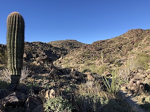


