When hiking several trails on a single "hike", log it with a generic name that describes the hike. Then link the trails traveled, check out the example.
WARNING! Hiking and outdoor related sports can be dangerous. Be responsible and prepare for the trip. Study the area you are entering and plan accordingly. Dress for the current and unexpected weather changes. Take plenty of water. Never go alone. Make an itinerary with your plan(s), route(s), destination(s) and expected return time. Give your itinerary to trusted family and/or friends.
Permit $$
None
Directions
Road
Strictly 4x4
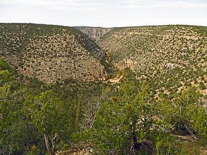
To hike From Payson, AZ- Hwy 260 East to Rim Road (FR300). Drive Rim Road to intersection of FR300/FR34. Drive FR34 North to intersection of FR34/FR63(Tilman Road). Left Turn onto FR63, then drive FR63 North to intersection of FR63/FR63B. Left Turn (NNW) onto FR63B. Drive 4WD and sometimes Slow/Rocky FR63B for 6.25 winding miles to road end at recommended Park/TH Start (no trail signage present- see & download above posted GPS Hiking Route-less traveled faint hiking trail does exist with some rock cairns present)..Note: Also see above posted GPS Driving Route with all "key way points" included.
page created by Grasshopper on Oct 19 2015 10:05 pm
 Route Editor


