username
X
password
register
for free!
help
 This is likely a great time to hike this trail!  Check out "Preferred" months below, keep in mind this is an estimate. 
  🔥

Pine Mountain 6814, AZ

Guide 20 Triplogs  0 Topics
  4.2 of 5  
Fav
Wish
0
details
drive
no permit
forecast
🔥
route  
stats
photos
triplogs
topics
location
162 20 0
Statistics
tap row or icons for details
Difficulty 0.5 of 5
Distance Round Trip 0.1 miles
Trailhead Elevation 6,749 feet
Elevation Gain 100 feet
Kokopelli Seeds 0.6
 Interest Off-Trail Hiking & Peak
feature photo
Photos Viewed All MineFollowing
Will recalculate on button tap!
20  2023-11-04
Pine Mtn Not a Trail Loop
chumley
11  2021-10-27
Pine - Turret Loop
LJW
10  2021-01-03
Pine Mountain Loop
AugustWest
60  2020-04-24
Pine Mountain Verde Rim Loop
outdoor_lover
14  2020-04-22
Pine Mountain 6814 Lasso Loop
DixieFlyer
13  2018-09-08
Nelson - Verde Rim - Salt Flat Loop
The_Eagle
15  2018-09-08
Nelson - Verde Rim - Salt Flat Loop
BiFrost
4  2018-04-26 FOTG
Page 1,  2,  3
Author
author avatar Guides 16,843
Routes 17,472
Photos 24
Trips 1 map ( 6 miles )
Age 28 Male Gender
Location HAZ, TrailDEX
Associated Areas
list map done
Camp Verde Region
Historical Weather
Trailhead Forecast
Radar Map
Expand Map
Preferred May, Sep, Oct, Jun
Sun  6:03am - 6:48pm
Official Route
 
11 Alternative
 
Historic Fire Perimeteracres
🔥 2005 Cave Creek Complex169.4 mi*


remove free decal offer
shorter than a pine tree
by HAZ_Hikebot

 Likely In-Season! 
Guide Needed
Publish Full Detail Guide


Use +Add above to share photos and triplogs
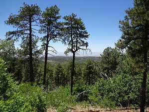
A 100 yard spur trail that climbs the final 100 feet to the 6814-foot summit of Pine Mountain with expansive views across the Verde River Valley and beyond.


    Check out the Official Route and Triplogs.
    Leave No Trace and +Add a Triplog after your hike to support this local community.
    WARNING! Hiking and outdoor related sports can be dangerous. Be responsible and prepare for the trip. Study the area you are entering and plan accordingly. Dress for the current and unexpected weather changes. Take plenty of water. Never go alone. Make an itinerary with your plan(s), route(s), destination(s) and expected return time. Give your itinerary to trusted family and/or friends.

     Permit $$
    no fees or permits reported

    if incorrect tell us about it


     Directions
    or
     Road
    Connector trail - Not Applicable

    To hike
    page created by chumley on Nov 12 2015 11:40 am
     90+° 8am - 6pm kills
    helpcorrectionissue

    end of page marker