Route Editor

| Guide | ♦ | 57 Triplogs | 0 Topics |
details | drive | no permit | forecast | 🔥 route |
stats |
photos | triplogs | topics | location |
| 76 | 57 | 0 |
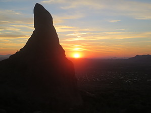
There is a big rock right there....go get on top of it by syoung  During a trip up Flatiron to clear the paint marks this past summer, I was chatting with JuanJamieiii as we trekked through the desert. As we gazed up at this impressive rock, he asked me if I had ever been up to the top. I scoffed at the notion while he assured me that it was not as difficult as it may appear. My first attempt was a few weeks later, and I quickly realized that he was right. Now, I must say that this is not the most difficult scramble to the top, but it is beyond a doubt one of the most exposed portions on the mountain. If the idea of taking a step to the right or left and tumbling off (most assuredly to an untimely demise), then this is definitely not the hike for you. During a trip up Flatiron to clear the paint marks this past summer, I was chatting with JuanJamieiii as we trekked through the desert. As we gazed up at this impressive rock, he asked me if I had ever been up to the top. I scoffed at the notion while he assured me that it was not as difficult as it may appear. My first attempt was a few weeks later, and I quickly realized that he was right. Now, I must say that this is not the most difficult scramble to the top, but it is beyond a doubt one of the most exposed portions on the mountain. If the idea of taking a step to the right or left and tumbling off (most assuredly to an untimely demise), then this is definitely not the hike for you.The hike approach begins at the Mining Camp parking lot, or if you are inclined to, you can begin at Lost Dutchman State Park. Head towards the Siphon Draw signage and head towards the mountain. The giant monolith that looms at the canyon's opening that leads into the mountain is your goal.
There is a turnoff at approximately 1.2 miles in. With the Gatekeeper looming to your right, look for a side trail that zooms downwards from the Siphon Draw main trail. The turnoff is directly in front of one of the railroad ties that cross the main trail to prevent erosion. You will begin boulder hopping now until you reach the slick rock of the stream bed. Make a sharp right and follow the stream bed for about 100 feet until you are standing at the bottom of the Gatekeeper's eastern face. Now here is the real gut-check time. Look up once, think twice, and turn back if you have any doubt at all. You will begin scrambling up this steep face. In my opinion, the best route up is following the crack all the way up until you hit the southern face. Upon reaching the southern face, you have the crux of this ascent facing you. I am not quite sure if I would call it a climbing pitch as much as a wall to clamber up. Find your way up the 8 or so feet, and you will dog leg to your right and hop up a 4-foot wall. You should now be facing towards Flatiron. Carefully, and I do mean carefully, make your way up the rock and badda bing, badda boom, you are on top of the Gatekeeper! Enjoy the views but don’t step too far in either direction. There is only room for 1 or 2 people up here at any one time. Make your way back down the way that you came. Check out the Official Route and Triplogs. Leave No Trace and +Add a Triplog after your hike to support this local community. | |||||||||||||||||||||||||||||||||||||||||||||||||||||||||||||||||||||||||||||||||||||||||||||||||||||||||||||||||||||||||||||||||||||||||||||||||||||||||||||||||||||||||||||||||||||||||||||||||||||||||||||||||