Overview
Short but steep, popular trail starting from the Pima Canyon parking lot. While the trails in the park are considered multi-use, horses and bikes would not be able to negotiate the steep western end of this trail.
History
Marcos De Niza Trail is named after the Spanish explorer who traveled the Southwestern US in 1539. There is an inscription on a rock near the eastern end of the trail that reads: "Friar Marcos de Niza corona todo el Nuebo Mexico a su costa ano de 1539." This translates to, "Friar Marcos de Niza crowned all of New Mexico at his expense in the year 1539." However, the writing style does not correspond to that era, nor was New Mexico referred to as New Mexico prior to the mid-1500s. Historians believe the inscription was made sometime after 1850, but prior to when it was discovered in 1920. A metal cage currently protects the rock. Numerous authentic Native American petroglyphs in the vicinity do not receive such protection.
Hike
The start of the trail is signed and is located on the southern edge of the Pima Canyon parking lot. There is no warm-up on this trail. It heads uphill immediately, switchbacking up the eastern side of the hill before heading west. There are several shortcuts through the switchbacks, but the main trail is obvious and easiest to ascend. The decomposed granite and sand can make for slippery footing at times.
Once you gain the ridge, the incline lessens, and you can catch your breath for a moment. Each little rise along the ridge leads you to believe you're reaching the high point, but then the next rise comes into view as you continue to head west. Views are good in all directions, and this is a nice area to view approaching summer storms from the south or east, as you can make a hasty last-minute retreat to your nearby vehicle.
After about two-thirds of a mile, you finally top out, then begin a slow descent along the ridge. Just before reaching the west end of the trail, it steeply drops down a chute/chimney, which requires a short scramble. There are plenty of hand and footholds, so the scramble is not an issue for most hikers. If you don't like that spot, you can veer slightly to your right and descend steeply down a somewhat more trail-like detour, but it ends up being the same amount of effort since you have to avoid sliding on the sandy granite.
Just beyond that steep section, the trail reaches the junction with Beverly Canyon Trail, easily identified by the power lines you are now standing beneath. Surprisingly, this junction is not signed at all. As of Spring 2021, the official Marcos De Niza Trail continues west past Beverly Canyon. While you are standing under the power lines, continue west on the obvious trail.
After crossing a small outcropping of rocks, the trail continues steeply uphill. Nearing the top of the first hill, the trail turns right, gets a little steeper, and continues towards the top of the next hill. Just before the top of that hill, the trail veers left and heads west along the top of the ridge as it mostly levels off. Continuing west along the ridge, the trail gradually climbs up to its terminus at the junction with the newly designated Guadalupe Perimeter Trail at the top of San Gabriel Ridge. From here, you can turn around, continue west along the ridge, or head south down San Gabriel.
When hiking several trails on a single "hike", log it with a generic name that describes the hike. Then link the trails traveled, check out the example.
WARNING! Hiking and outdoor related sports can be dangerous. Be responsible and prepare for the trip. Study the area you are entering and plan accordingly. Dress for the current and unexpected weather changes. Take plenty of water. Never go alone. Make an itinerary with your plan(s), route(s), destination(s) and expected return time. Give your itinerary to trusted family and/or friends.
Permit $$
None
Directions
Road
Paved - Car Okay
To Pima Canyon Trailhead To Pima Canyon Trailhead
This one is a little tough to locate if you're not from the area. It's near Guadalupe Rd. The issue at hand is there are no on-off ramps for Guadalupe Rd. Instead, get off south a mile on Elliot and follow 48th Street north.
Pima Canyon Trailhead is located west off of 48th Street, just south of Guadalupe Road. It's all somewhat confusing. Your first time, go to the intersection of Guadalupe & 48th, then head south. Take the first right and an immediate left into South Mountain/Phx Preserves Park. Follow the access road passing the golf course all the way to the trailhead.
Pima Canyon Trailhead and Marcos de Niza Trailhead are the same now. Long ago, the road continued to Pima Canyon Trailhead.
From PHX (I-10 & AZ-51) 10.9 mi - about 18 mins From TUC (Jct 1-10 & Grant) 101 mi - about 1 hour 32 mins From FLG (Jct I-17 & I-40) 155 mi - about 2 hours 25 mins
page created by trekkin_gecko on Mar 30 2021 6:35 pm
 Route Editor

 Overview
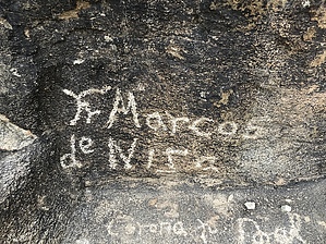


