This is a modest but nice little rewarding peak that can be reached via the Cave Creek/Seven Springs trailhead. A little extra effort is required to reach this peak with approximately 1.5 miles of off-trail each way. Most will find the first half mile of off-trail the toughest, as one makes the initial off-trail climb up a distinct ridgeline that runs down to Quien Sabe Trail #250.
The climb is not overly bad, as there is a relatively distinct game trail the entire length of the ridgeline. However, the footing will never be overly stable with several ankle breakers to contend with and terrain similar to that of Skull Mesa with pin cushion cacti and agave lurking in the tall grass. However, after the quick climb up the thin ridgeline, the off-trail route becomes very manageable and fast going. There is nearly a mile-long stretch of flat grassy ground with several game trails to ease travel. The peak sits at the end of this long mesa-like stretch and only requires an easy climb up a modest slope.
There are several other options for reaching the summit. One can summit via the Cottonwood Trail #247, utilizing the Bronco Trailhead, or exit Skunk Tank Trail #246 much earlier than its intersection with Quien Sabe and utilize the Quien Sabe Creek drainage. I exited the summit via the aforementioned Quien Sabe Creek and would not recommend that as an ascent route. It is very steep near the top and one will not have the advantage of being able to see the game trails more clearly, as they do when coming down this side. The posted official route is less direct, however, far more straightforward and much easier.
When hiking several trails on a single "hike", log it with a generic name that describes the hike. Then link the trails traveled, check out the example.
WARNING! Hiking and outdoor related sports can be dangerous. Be responsible and prepare for the trip. Study the area you are entering and plan accordingly. Dress for the current and unexpected weather changes. Take plenty of water. Never go alone. Make an itinerary with your plan(s), route(s), destination(s) and expected return time. Give your itinerary to trusted family and/or friends.
Permit $$
no fees or permits reported
if incorrect tell us about it
Directions
Road
To Cave Creek Seven Springs Trailhead Cave Creek TH in the Seven Springs Campground area.
From the intersection of Tom Darlington Rd and Cave Creek Rd, travel East on Cave Creek Rd. At 2.2 miles, you pass Pima Rd. Continue on Cave Creek Rd, and at 6.3 miles, you reach Bartlett Dam Rd. Follow the sign to Seven Springs Rd. At 9.1 miles, you pass the Sears Kay Ruins. The pavement ends at 10.8 miles. You pass the Bronco TH at 13.8 miles, and the road is now marked Forest Road 24. At 17.6 miles, you pass a private ranch. At 17.9 miles, you pass the Seven Springs Campground, and the Cave Creek TH is on your left at 18.5 miles.
2012-03-07 Nahimana222 writes: From the signs I saw at the trailhead, you need a Tonto Pass to park. 2025-11-27 kyleGChiker writes: As of this date, the Forest Service website indicates that this is a fee-free area, with no pass required.
From PHX (I-10 & AZ-51) 51.5 mi - about 1 hour 36 mins From TUC (Jct 1-10 & Grant) 153 mi - about 2 hours 57 mins From FLG (Jct I-17 & I-40) 127 mi - about 2 hours 38 mins
 Route Editor


 This is a modest but nice little rewarding peak that can be reached via the Cave Creek/Seven Springs trailhead. A little extra effort is required to reach this peak with approximately 1.5 miles of off-trail each way. Most will find the first half mile of off-trail the toughest, as one makes the initial off-trail climb up a distinct ridgeline that runs down to Quien Sabe Trail #250.
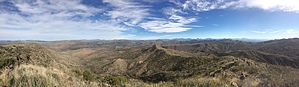


