 Route Editor

| Guide | ♦ | 4 Triplogs | 0 Topics |
details | drive | no permit | forecast | route |
stats |
photos | triplogs | topics | location |
| 40 | 4 | 0 |
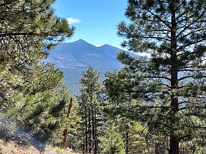
flap like a bird by HAZ_Hikebot  I wanted to get to the top of Wing Mountain with my radio gear for Summits on the Air. There was a decent amount of snow on the ground and I didn’t know if I would be able to get close enough to the base due to a bunch of road closures in the area. I wanted to get to the top of Wing Mountain with my radio gear for Summits on the Air. There was a decent amount of snow on the ground and I didn’t know if I would be able to get close enough to the base due to a bunch of road closures in the area.I drove to FR 222 and found it closed so I drove up to 222B. The Wing Mountain Snow Play Area was in operation and they were kind enough to let me park at the entrance and hike in through the sledding area without paying.
Check out the Official Route and Triplogs. Leave No Trace and +Add a Triplog after your hike to support this local community. One-Way Notice This hike is listed as One-Way. When hiking several trails on a single "hike", log it with a generic name that describes the hike. Then link the trails traveled, check out the example. | ||||||||||||||||||||||||||||||||||||||||||||||||||||||||||||||||||||||||||||||||||


