Route Editor

| Guide | ♦ | 9 Triplogs | 1 Topic |
details | drive | permit | forecast | route |
stats |
photos | triplogs | topic | location |
| 303 | 9 | 1 |
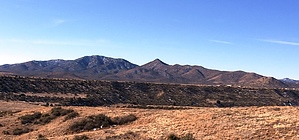
  Sun Devil Peak (6903') is one of the high summits of the northeasternmost ridgeline of the Bradshaw Mountain Range. This range is easily seen from Highway 69, starting from Poland Junction (MP 275) and looping around to just before Cost Co (MP 293). These mountains are bounded by Diamond Valley and Prescott Valley on the north; Dewey-Humboldt to the east; Mayer to the southeast; Breezy Pines & Poland Road to the south; and the Walker valley/Lynx Lake to the west. Sun Devil Peak (6903') is one of the high summits of the northeasternmost ridgeline of the Bradshaw Mountain Range. This range is easily seen from Highway 69, starting from Poland Junction (MP 275) and looping around to just before Cost Co (MP 293). These mountains are bounded by Diamond Valley and Prescott Valley on the north; Dewey-Humboldt to the east; Mayer to the southeast; Breezy Pines & Poland Road to the south; and the Walker valley/Lynx Lake to the west.Aerial view of its mountain top instantly reminds you of a slightly slanted pitchfork. The east-west summit ridge has a single main south-ridge while on its north flanks protrudes three fork ridges. There is no trail to the summit. Opportunities to the summit are endless and depend on your liking. There are two main drainages (in between the three north forks), predominately tabled granite with seasonal water flows. The northeast fork ridgeline is the closest line to the trailhead. T Vegetation in the area is predominately chaparral; manzanita; pine trees, and an occasional alligator juniper, all of which are very old. The geology of the area is mainly Precambrian Granite.
The Charcoal Gulch Trail is used predominately by off-road motorcycles, quads, and horseback. The area is also heavily used by hunters. Trailhead is from the Prescott National Forest's "proposed" Newtown Trailhead. Currently, the Trailhead is a small parking lot that is at the end of Newtown Road. This is the official trailhead for Charcoal Gulch Trail #9419. There is a quad trail from the TH gate, and just south of the road is a footpath. This footpath later connects onto the quad trail. From the TH, continue west on Charcoal Gulch Trail #9419 for just under 1 mile when it goes down into "Green Gulch", the major east flowing drainage for the area. From here, you have options; 1) you can stay on Charcoal Gulch trail due south for another half mile and connect to the northeast fork ridgeline and go "off-trail" from there, or 2) meander south-southwest onto another trail for about 1/2 mile (1.47 miles from TH; elevation 5325') which places you directly in front of the east fork ridgeline. If the plan is to visit the plane wreckage, stay on the drainage that goes west, then southwest, the south. You will exit the drainage and bank-left at 2.26 miles from TH (6326'). The wreckage will be found as you traverse south and southeast up the ridgeline. UPDATE: 9/8/2016 The proposed Newtown Trailhead is officially called the Green Gulch Trailhead. A dedication ceremony was scheduled for Saturday, September 10, 2016, at 1 PM. Turn around often; the views as you climb keep getting better and better. First, you see Prescott Valley & Dewey. Upper ridges provide views to the unnamed 6548, which constantly lets you know he's there (the nearest northern peak). Further up is Diamond Valley and Glassford Hill. As you approach the summit, you see Granite Mountain, Prescott, Willow Lake, and Mayer. When you get to the summit, views to Walker Valley, Spruce Mountain, and Mount Union summit towers. The mountain immediately south is unnamed 6962'. Gate Policy: If a gate is closed upon arrival, leave it closed after you go through. If it is open, leave it open. Leaving a closed gate open may put cattle in danger. Closing an open gate may cut them off from water. Please be respectful, leave gates as found. The exception is signage on the gate directing you otherwise. Check out the Official Route and Triplogs. Leave No Trace and +Add a Triplog after your hike to support this local community. | |||||||||||||||||||||||||||||||||||||||||||||||||||||||||||||||||||||||||||||||||||||||||||||||||||||||||||||||||||||||||||||||||||||||||||||||||||||||||||||||||||||||||||||||||||||||||||