Route Editor

| Guide | ♦ | 1 Triplog | 0 Topics |
details | drive | no permit | forecast | route |
stats |
photos | triplog | topics | location |
| 13 | 1 | 0 |
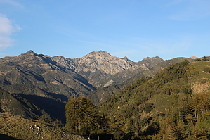
Incredible Views of an Incredible Place by JimmyLyding Walk uphill from the dirt parking lot towards the inn until you see a dirt road branching off to the right just past the wedding area to an electric gate with some signage and a pedestrian walk through. This gate keeps out the riffraff, but allows access to the sporadic residences along the Coast Ridge Road which is what you're hiking on. The first half of this hike is basically all uphill, but it's not a tough grade. Continue up the semi-maintained dirt road with the posh grounds of the Ventana Inn on the left and views of Hwy. 1 and the coast way down on the right until the road enters a nice redwood grove. This spot is about 40 miles north of the coast redwood's southernmost limit, but surprisingly there are a few old growth specimens. A canyon gains prominence on the left with a few of these giant trees rising from the bottom far below to a hundred feet above the trail. Most trees are second- and third growth, however.
However, the most impressive sight may be that of Ventana Double Cone in the heart of the Ventana Wilderness. This prominent mountain would look at home in the Sierra Nevadas, but its journey began closer to the Sierra Madre in Mexico. Plate tectonics transformed sediment that was deposited on the west coast of what is now Mexico to travel almost 2,000 miles north its present location. Ventana Double Cone does not look like a stratovolcano as one might expect, but just a jagged, rocky prominence on a high ridge. The dirt road now heads south then east for about another mile with stupendous views to the south of the Pacific. The road is now close to the top of the ridge that hides views of the high peaks. This hike basically ends at the upper trail head of the Terrace Creek Trail about 4 miles in at the top of the ridge. There are a few residences here, but they are unobtrusive. There are nice spots for breaks about 0.5 mile past the trail head and 0.25 mile back down in open spots on top of the meandering ridge. Return the way you came, and enjoy the ride home. This hike passes about a dozen homes so please respect private property rights. Gate Policy: If a gate is closed upon arrival, leave it closed after you go through. If it is open, leave it open. Leaving a closed gate open may put cattle in danger. Closing an open gate may cut them off from water. Please be respectful, leave gates as found. The exception is signage on the gate directing you otherwise. Check out the Official Route and Triplog. Leave No Trace and +Add a Triplog after your hike to support this local community. | ||||||||||||||||||||||||||||||||||||||||||||||||||||||||||||||||||||||||||||||||||||||||