Route Editor

| Guide | ♦ | 12 Triplogs | 0 Topics |
details | drive | no permit | forecast | route |
stats |
photos | triplogs | topics | location |
| 146 | 12 | 0 |
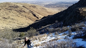
Dont Forget to Hit the Cave by Peter_Medal   May 2016 Note May 2016 NoteThere is now an official designated trail. The following was written before the trail was complete. On your way to Prescott, driving on Highway 69 through Prescott Valley, you pass a grassy hill with a car dealership, a hotel, and condos carved into the lower southwest flanks. The hill looks like a little hill, no prominence, just boring. On the contrary, it is big and massive. Its south face melts quickly during snow season. Its north face stays white, almost an exact line. The hill does not even look very high. On the contrary, its elevation gain is actually almost as high as Squaw Peak in Phoenix.
Archeological evidence of early man goes back as far as 800 A.D. Ancient Indian villages were settled around Glassford Hill in 1400. The U.S. Cavalry established Fort Whipple 5 miles away. Colonel William A. Glassford traveled the area in the 1880s and helped build a system of 7 heliograph stations to monitor the movements of Apache Indians, U.S. military troops, and civilians. GH was a part of that early communications system, using signal mirrors to communicate with other army units in the war against the Apaches. FEB 2016: The Town of Prescott Valley is in process of carving out the road like switchbacks to the saddle between the south ridgeline summit and the GH summit south ridgeline. It reminds me of the paved road to the summit of North Mountain in Phoenix. This area will soon be a city-run "preserve" with roads and biking trails. The road terminates at the south ridgeline summit. We noted a series of survey flag stakes for the future "GH Trail". Researching current activity, I was only able to find a town council approval of the proposed development of making GH a city preserve park (August 2015). However, graders and backhoes diligently worked on the switchbacks, so the Town is going full throttle on development for the future city "preserve" and trail. Until then, as it is today, there is a smallish parking area in front of the bridge with a locked gate (to vehicles) but permissible for pedestrian access. This bridge is located west of the intersection of Antelope Lane and North Castle Drive in Prescott Valley, AZ. West of the bridge, there is a road that is under construction. THE HIKE: Follow this road about 0.53 miles to a fenced-off water tank. For the non-off road or not off-trail hiker, you can take the road that is under construction which terminates on the summit of the south ridgeline). West past the fenced water tank, make a bee-line straight line towards the drainage. The ascent after the drainage is 0.94 miles from the TH. Suppose you look up for a sole green tree that's your line up to the nub. The word from many locals is GH is a snake haven. The grassy topography is probably not an ideal hike for spring, summer, or fall if you're afraid of rattlesnakes. The inner climb is not much of a bushwhack, open and spacy chaparral, and sturdy volcanic rock. Pass the lone green tree, bank slight left, and onto a rock climb boulder hoppers playground. A HAZ guest register is situated on the nub summit. Not quite there, from the nub, you continue west down then up to the GH summit. The official high point (6178') is on a rock pile with a "monument sign" posted on it, located within a fenced compound or cell/radio towers and lots of solar panels. There is no public access. West of the fenced compound offers some fantastic views of Prescott, Willow Lake, Watson Lake, Granite Mountain, The Dells, and Thumb Butte. To the south: Sun Devil Peak, Walker, Spruce Mountain & Mount Union summit towers, and Mount Tritle. OPTIONAL CAVE ROUTE: If you look up due south 0.89 miles from TH, you can see the cave opening as you approach the nub ascent. Getting to the cave from the GH summit, loop around to the South ridgeline. There is a road leading to its summit that is under construction. The cave will be on the north side of the south ridgeline about 1/2 mile SE. Cave GPS: 34.58926, -112.37404 Cave elevation is 5917' Gate Policy: If a gate is closed upon arrival, leave it closed after you go through. If it is open, leave it open. Leaving a closed gate open may put cattle in danger. Closing an open gate may cut them off from water. Please be respectful, leave gates as found. The exception is signage on the gate directing you otherwise. Check out the Official Route and Triplogs. Leave No Trace and +Add a Triplog after your hike to support this local community. | ||||||||||||||||||||||||||||||||||||||||||||||||||||||||||||||||||||||||||||||||||||||||