username
X
password
register
for free!
help


Mule Hoof Ruins, AZ

Guide 4 Triplogs  0 Topics
  4.7 of 5  
Fav
Wish
4
details
drive
no permit
forecast
route  
stats
photos
triplogs
topics
location
79 4 0
HAZ reminds you to respect the ruins. Please read the Archaeological Resources Protection Act of 1979 & Ruins Etiquette
Statistics
tap row or icons for details
Difficulty 3 of 5
Route Finding 3 of 5
Distance One Way 1.2 miles
Trailhead Elevation 4,719 feet
Elevation Gain 700 feet
Accumulated Gain 979 feet
Avg Time One Way 4.5hrs R/T
Kokopelli Seeds 4.46
 Interest Off-Trail Hiking, Ruins, Historic, Perennial Creek & Peak
feature photo
Photos Viewed All MineFollowing
Will recalculate on button tap!
7  2017-10-31 GeeEss
30  2016-02-13 ssk44
36  2016-02-13 Grasshopper
5  2016-02-13
Upper Phillips Mines History Meander
Grasshopper
1  2016-02-12 ssk44
Author
author avatar Guides 16,843
Routes 17,472
Photos 24
Trips 1 map ( 6 miles )
Age 28 Male Gender
Location HAZ, TrailDEX
Associated Areas
list map done
Globe Region
Historical Weather
Trailhead Forecast
Radar Map
Expand Map
Preferred Apr, Mar, Nov, Oct
Sun  5:58am - 6:44pm
Official Route & 1 Rt
 
2 Alternative


remove free decal offer

  
Guide Needed
Publish Full Detail Guide


Use +Add above to share photos and triplogs
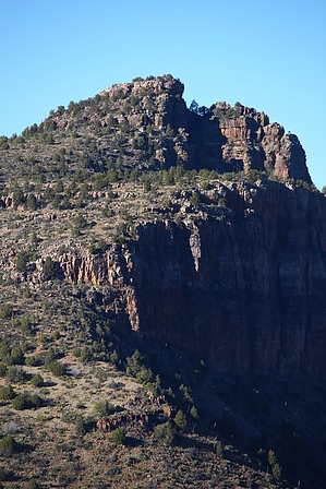
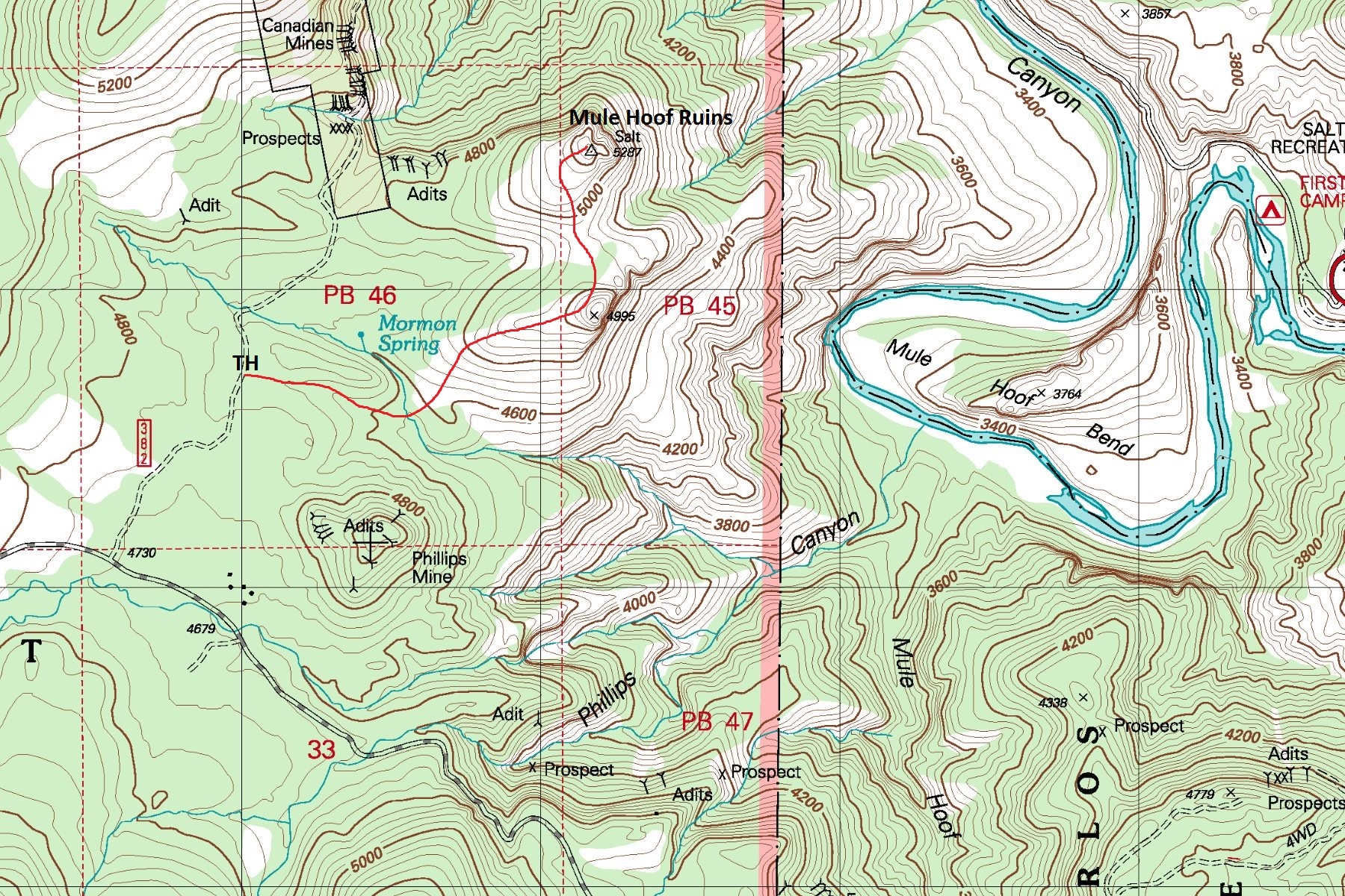
Remote scenic Indian ruin site located high above Salt River Canyon within the Tonto National Forest. The ruins are perched atop a small rugged cliff lined butte. Reaching the ruins requires negotiating a short class 3 scramble. A great destination for those with a love for ancient Indian history and off-trail adventure.


  • guide related image
    guide related


Check out the Official Route and Triplogs.
Leave No Trace and +Add a Triplog after your hike to support this local community.

One-Way Notice
This hike is listed as One-Way.

When hiking several trails on a single "hike", log it with a generic name that describes the hike. Then link the trails traveled, check out the example.
WARNING! Hiking and outdoor related sports can be dangerous. Be responsible and prepare for the trip. Study the area you are entering and plan accordingly. Dress for the current and unexpected weather changes. Take plenty of water. Never go alone. Make an itinerary with your plan(s), route(s), destination(s) and expected return time. Give your itinerary to trusted family and/or friends.

 Permit $$
no fees or permits reported

if incorrect tell us about it


 Directions
or
 Road
High Clearance possible when dry

To hike
From Globe.. US60 - Senaca Lake (San Carlos Apache Tribe) - Indian Route 1302 (1.3 Miles) - Tonto National Forest Boundary - FR473 (Phillips Mine Road) - FR382 (Canadian Mine Road) - Trailhead

*Note: Traveling along the 1.3 mile segment of Indian Route 1302 from US60 is legal without a tribal permit if no stops for recreation of any kind are made.
page created by ssk44 on Feb 13 2016 11:07 pm
 90+° 8am - 6pm kills
helpcorrectionissue

end of page marker