 Route Editor

| Guide | ♦ | 11 Triplogs | 0 Topics |
details | drive | no permit | forecast | route |
stats |
photos | triplogs | topics | location |
| 122 | 11 | 0 |
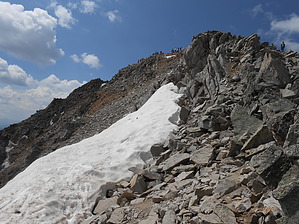
Go on a Weekday! by rvcarter Huron Peak barely makes it to the 14er class, coming in at 14,003 feet above sea level. Only Sunshine Peak in the San Juans is lower. It’s located a little under 3 miles south of historic Winfield, Colorado, in the Collegiate Peaks Wilderness portion of the San Isabel National Forest (Sawatch Range). The peak is on the border of the wilderness area and the trail is just outside the area, but you can’t tell the difference. Winfield is over 14 miles west of the north/south U.S. 24 at the end of Chaffee County Road #390, a gravel surface road that gets rougher as you get closer to Winfield. Hike This description is for the most popular route to Huron, called the Northwest Slopes route, which begins at the South Clear Creek Trailhead. Getting to the SCC Trailhead requires a high clearance vehicle and 4WD most of the year. The day I was there (during the summer), I had to park my 2WD truck about 0.5 miles out of Winfield and walk along the South Fork Clear Creek Road (390.2B) to reach the TH, adding over 3 miles RT to my hike. It’s an easy, nearly level walk though, and seems to go pretty quick, but it adds over 300 feet of elevation gain. There are ample camping spots near the trailhead if you want to make a night of it. Lots of water sources.
As with other 14ers I’ve done, the views from the top are magnificent. It is a truly wonderful experience to be on top of one of these on a clear day in good weather. Huron is the easiest one or two (of a dozen or so) 14ers I’ve done. It's class 2 difficulty rating is only slightly higher than 8 other 14er routes with class 1 ratings. I HIGHLY recommend going during the week. The easier 14er Colorado peaks are deluged on weekends (I went on a Saturday). There are people and dogs all over the place. Note There are two other routes to Huron Peak(not covered here), also class 2, but both longer and harder. The Southwest Slopes and North Ridge from Lulu Gulch. Second note: A good (navigation friendly) map of the road in from Winfield and the trail described here is published by National Geographic – Buena Vista Collegiate Peaks #129. Good Huron maps are also available from commercially available Alltrails/National Geographic software. Warning Storms accompanied by lightning are nearly a daily occurrence in mountainous Colorado. Many hikers are struck by lightning each year. The rule of thumb is to be well off the peak before noon, but you should look at weather forecasts before starting and watch the sky while on the trail. Check out the Official Route and Triplogs. Note This is a moderately difficult hike. Leave No Trace and +Add a Triplog after your hike to support this local community. One-Way Notice This hike is listed as One-Way. When hiking several trails on a single "hike", log it with a generic name that describes the hike. Then link the trails traveled, check out the example. | ||||||||||||||||||||||||||||||||||||||||||||||||||||||||||||||||||||||||||||||||||||||||||||||||||||


