Route Editor

| Guide | ♦ | 5 Triplogs | 1 Topic |
details | drive | permit | forecast | 🔥 route |
stats |
photos | triplogs | topic | location |
| 134 | 5 | 1 |
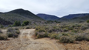
Freestyle Down to Grapevine Falls by Peter_Medal   Big Bug Mesa (BBM) is 3 miles wide from east to west and 2 miles wide from north to south in the east-central highlands of the Bradshaw Mountain Range. It is easily viewed from Mt. Union; Mt. Davis or Moscow Peak to the west. Grapevine Canyon carves out much of its NW quadrant. It's big. It's flat, and its top is covered with a thick pine forest. BBM average elevation is about 6900'. The mesa can be accessed via motor vehicle from the following routes: From Walker, AZ; take Big Bug Mesa Road to "Five Corners" then the southeast fork up and onto the Mesa; From Prescott; take the Senator Highway to Forest Road 261 east to "Five Corners". From Mayer/Dewey-Humboldt take Highway 69 to Poland Junction (MP 275); west through "Breezy Pines" to "Five Corners". Only Forest Road 261 would require a High Profile Vehicle. The roads on BBM are fairly tame. Big Bug Mesa (BBM) is 3 miles wide from east to west and 2 miles wide from north to south in the east-central highlands of the Bradshaw Mountain Range. It is easily viewed from Mt. Union; Mt. Davis or Moscow Peak to the west. Grapevine Canyon carves out much of its NW quadrant. It's big. It's flat, and its top is covered with a thick pine forest. BBM average elevation is about 6900'. The mesa can be accessed via motor vehicle from the following routes: From Walker, AZ; take Big Bug Mesa Road to "Five Corners" then the southeast fork up and onto the Mesa; From Prescott; take the Senator Highway to Forest Road 261 east to "Five Corners". From Mayer/Dewey-Humboldt take Highway 69 to Poland Junction (MP 275); west through "Breezy Pines" to "Five Corners". Only Forest Road 261 would require a High Profile Vehicle. The roads on BBM are fairly tame.Its prominent North USGS elevation is 7045' (overlooking Breezy Pines); East is 6908' (overlooking Grapevine Canyon to the north); Southwest is 6746' (overlooks Wolf Creek/Canyon to the south); and finally Southeast is 6743' (overlooking Taft Canyon). This hike description is for the BBM summit bag of its East prominence.
GRAPEVINE CANYON TRAILHEAD: The sign describes the unique habitat the Grapevine Canyon maintains. This is also the official trailhead for Trail #4. Take Trail #4 for just about 1/3 of a mile until you hit a fork in the trail. Trail #9434 will fork left and south; Trail #4 will continue west, meandering along the north side of the Grapevine Creek. This junction will be your lasso loop if you will be returning from Grapevine Falls. Getting on the BBM east ridgeline trail from Trail #9434 is a little tricky. #9434 continues south; almost immediately after traversing the drainage, you will need to veer right/west and look for the ridgeline that pushes up. Once on the ridgeline trail, it pushes up to the top of the Mesa, in 1.1 miles with about 1500' in elevation gain. Predominately folded crumbly granite this trail provides a nice footing and easy gripping. It's in full sun once above the tree line with little to no relief. Turnaround often, the views to Mayer; Dewey-Humboldt; Prescott Valley just keep getting better and better. Once on Mesa, you will meander south and stumble upon the "Battleship Rock". It's a fun little playground for climbers and a great place to stop for a break. Continue West to capture 6908' for another 1/2 mile. GRAPEVINE FALLS OPTION: Once summiting the Mesa top; continue north for the edge of the Mesa, overlooking the Grapevine Canyon. The freestyle drop will have a few down climbs on big granite boulders. The best bet would be to stay outside the Oak thickets and follow the older Pines in a north-northeast line. About 1/2 way down into the Canyon you will hear the sounds of the flowing creek; springs and waterfalls. Stay on the south side and above the drainage; you will pick up previous paths. Once down by the falls; there is a creekside trail the runs on the northside of the creek that runs east and west; stay on this path east and it eventually connects to Trail #4 and back to the Trailhead. Check out the Official Route and Triplogs. Leave No Trace and +Add a Triplog after your hike to support this local community. | |||||||||||||||||||||||||||||||||||||||||||||||||||||||||||||||||||||||||||||||||||||||||||||||