Route Editor

| Guide | ♦ | 2 Triplogs | 1 Topic |
details | drive | permit | forecast | route |
stats |
photos | triplogs | topic | location |
| 84 | 2 | 1 |
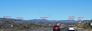
Bushwackers Paradise by Peter_Medal   Mount Elliott (6980') is the prominent peak to the west, overlooking the Highway 69 Corridor between Mayer and Dewey-Humboldt. It is in an unincorporated area of Yavapai County and situated in the Prescott National Forest just north of the "Breezy Pines" community. It is bounded on the south side by Eugene Gulch just off Poland Road, followed by Eugene Ridgeline. The Eugene Mine is located on its southern flanks. Forest Trail 20 meanders along Eugene Gulch. Its west ridgeline drains into the Walker Valley, where Big Bug Mesa Road terminates at Walker Road. Its north ridgeline flares NE and drains into the Chaparral Gulch. Bear Down Mountain (6962') is about 3 miles north of its summit, followed by Sun Devil Peak (6903'). Four miles east of its summit is Highway 69. There are various named and unnamed jeep trails or forest service road or hike trails on its east flank (9404T; 9430; and 9429). Its major east flowing drainage is Ticonderoga Gulch which is home to Mount Elliott Spring. The Gulch is a flowing creek during the winter from snow runoff. Mount Elliott (6980') is the prominent peak to the west, overlooking the Highway 69 Corridor between Mayer and Dewey-Humboldt. It is in an unincorporated area of Yavapai County and situated in the Prescott National Forest just north of the "Breezy Pines" community. It is bounded on the south side by Eugene Gulch just off Poland Road, followed by Eugene Ridgeline. The Eugene Mine is located on its southern flanks. Forest Trail 20 meanders along Eugene Gulch. Its west ridgeline drains into the Walker Valley, where Big Bug Mesa Road terminates at Walker Road. Its north ridgeline flares NE and drains into the Chaparral Gulch. Bear Down Mountain (6962') is about 3 miles north of its summit, followed by Sun Devil Peak (6903'). Four miles east of its summit is Highway 69. There are various named and unnamed jeep trails or forest service road or hike trails on its east flank (9404T; 9430; and 9429). Its major east flowing drainage is Ticonderoga Gulch which is home to Mount Elliott Spring. The Gulch is a flowing creek during the winter from snow runoff.The Mountain is cone-shaped and predominately pre-Cambrian granite and covered with high-desert scrub; chaparral; prickly pear; manzanita; and alligator juniper. The first 1.3 miles is a trail, then off-trail for 0.9 miles to the summit, and a bushwhackers paradise. In the significant drainages off its peak, provide for some non-technical rock climbing. The summit hike/climb options are numerous.
Mining claims (private property), as noted on the USGS maps, consume much of its foothills between 5400' to 5800' (at about 3:15 to 6:00 of its summit). To avoid crossing private property, I am noting three routes from the Eugene Gulch/Poland Road TH: (NOTE: This access does not require 4WD or High-Profile Vehicles to access TH) Another option would be to take 9429 north about 1 mile, then WNW up its middle drainage. Other approaches include from the Walker Community off Big Bug Mesa Road (west ridgeline) or from the Northeast via some unnamed jeep trails (some may require high-profile vehicles), namely via Ticonderoga or Galena Gulches. Check out the Official Route and Triplogs. Leave No Trace and +Add a Triplog after your hike to support this local community. | |||||||||||||||||||||||||||||||||||||||||||||||||||||||||||||||||||||||||||||||||||||||||