| Guide | ♦ | 3 Triplogs | 0 Topics |
details | drive | no permit | forecast | route |
stats |
photos | triplogs | topics | location |
| 23 | 3 | 0 |
The Silver Peak by rvcarter The West Winfield Trailhead (marked “La Plata South” on Nat. Geo. # 129, Buena Vista Collegiate Peaks Trails Illustrated Map) is small and very hard to reach, even during dry conditions. The TH is nothing more than a small wooden board that suggests little maintenance or upkeep , but it does signal the starting point. On the plus side, there are lots of camping opportunities past Winfield.
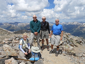
It seemed to be about a half mile through the bog, but could be less since the going was slow. Past the bog, you can see the trail which climbs very steeply to the ridge. Be careful here because of the loose rock, especially on the way down. All of us hit the deck coming down at least once. At the ridge the trail turns 90 degrees northeast, and becomes more boulder-ie as you climb. You arrive at the next steepest part a little over a half mile after reaching the ridge. There are numerous paths and cairns up the ridge. There is nothing above Class 2 and little exposure (Class 2) from here up, just fun scrambling. Don’t worry, keep heading up; all trail variants lead to the peak. The trail joins the Northwest Slopes route (#1474) for the last tenth mile or so. Expect patches of snow near the top, even in July. This is a very popular hike during the summer, so expect to see lots of friends at the top, especially on weekends. The route described here is definitely less crowded than the standard Northwest Slopes route. The views once you get above tree line and at the top are magnificent in every direction. Take time at the top, if the sky is clear, to enjoy this special place. Note: This description does not cover the Northwest Ridge (the “standard”) or Ellingwood Ridge routes to La Plata Peak, which begin east of Independence Pass off Colorado Hwy #82. Both these latter routes are longer and harder; Ellingwood Ridge is a significant step up in terms of difficulty (Class 3) and exposure (Class 4) (which probably explains why my climbing buds want to do that one). Warning: Storms accompanied by lightning, are nearly a daily occurrence in mountainous Colorado. Many hikers are struck by lightning each year. The rule of thumb is to be well off the peak before noon, but you should look at weather forecasts before starting out and watch the sky while on the trail. Check out the Official Route and Triplogs. Leave No Trace and +Add a Triplog after your hike to support this local community. One-Way Notice This hike is listed as One-Way. When hiking several trails on a single "hike", log it with a generic name that describes the hike. Then link the trails traveled, check out the example. | ||||||||||||||||||||||||||||||||||||||||||||||||||||||||||||||||||||||||||||||||||||||||||||||
 Route Editor


