Route Editor

| Guide | ♦ | 8 Triplogs | 1 Topic |
details | drive | permit | forecast | route |
stats |
photos | triplogs | topic | location |
| 76 | 8 | 1 |
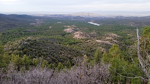
Lynx Lake Observation Deck by Peter_Medal   Bigelow Peak (6731') is a part of the Bradshaw Mountains in the Prescott National Forest. Its prominence reveals itself about a 1/4 mile past milepost 2 traveling south on Walker Road until out of sight behind Smith Ravine. Its summit is just over 2 miles south-southwest from Lynx Lake; 2.5 miles north of Spruce Mountain (7696') and 2 miles NNE of the summit of Bald Mountain (7298'). The peak is bounded by Sawmill Gulch (half-mile +/-) to the west; Benjamin Gulch (1 mile) on the north; Walker Road on the east (1 to 1.5 miles); and Smith Ravine (1 mile +/-) to the south. Bigelow Peak (6731') is a part of the Bradshaw Mountains in the Prescott National Forest. Its prominence reveals itself about a 1/4 mile past milepost 2 traveling south on Walker Road until out of sight behind Smith Ravine. Its summit is just over 2 miles south-southwest from Lynx Lake; 2.5 miles north of Spruce Mountain (7696') and 2 miles NNE of the summit of Bald Mountain (7298'). The peak is bounded by Sawmill Gulch (half-mile +/-) to the west; Benjamin Gulch (1 mile) on the north; Walker Road on the east (1 to 1.5 miles); and Smith Ravine (1 mile +/-) to the south.Its summit ridge is a 1/ 4 mile long and traverses from east to west. Its true summit is on the west end of its 3 peak prominence.
The mountain is predominately granite, covered with an old grove of sparsely populated juniper and pines, lots of Manzanita, and thick Chaparral. Unlike its neighboring peaks which are covered with lots of Mountain berry or New Mexico Locust, Bigelow is covered with Gambel Oak and Chaparral thickets. There is a large granite outcropping west of the center on its north flank. There is a large crack, almost like a chute. This peak provides the absolute best views of Lynx Lake followed by Glassford Hill (6178'). Research into its name did not reveal any data on how its name came into being. Unlike much of the Walker area, this mountain did not have any mines on it. Check out the Official Route and Triplogs. Leave No Trace and +Add a Triplog after your hike to support this local community. | ||||||||||||||||||||||||||||||||||||||||||||||||||||||||||||||||||||||||||||||||||||||||||||