Route Editor

| Guide | ♦ | 1 Triplog | 0 Topics |
details | drive | no permit | forecast | route |
stats |
photos | triplog | topics | location |
| 8 | 1 | 0 |
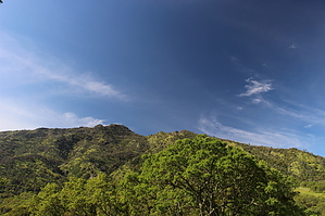
Rough Hike To A Nice Little Peak by JimmyLyding  This hike starts on Three Springs Road which is paved, but behind the gate on Marsh Springs. There are trail signs here, but they didn't always agree with what my map shows. The paved trail winds around a small ridge, and leisurely climbs a few hundred feet to about the 3/4 mile mark where the pavement heads steeply down to a residence with a spur heading off to the right. The vegetation changes to oak woodland as soon as the trail starts going up, and there are several scenic meadows. Go right on what the sign refers to as the Olympia Trail, but my map refers to as Wise Road as it winds through the oak forest to where it seemingly ends after a hairpin turn at a junction to the road to another private residence.
The view from the top is superb, and you are likely to encounter other hiking souls. Return the way you came if you want to test your ability to avoid poison oak again or head down and north on the Olympia Road to its junction with the East Trail that you've already visited before. Be careful to follow the signs to stay on Olympia Road as it switchbacks down the mountain to its junction with the Olympia Trail. The trail heads back to the junction with the East Trail, and is a good way to add a little variety to this hike. Gate Policy: If a gate is closed upon arrival, leave it closed after you go through. If it is open, leave it open. Leaving a closed gate open may put cattle in danger. Closing an open gate may cut them off from water. Please be respectful, leave gates as found. The exception is signage on the gate directing you otherwise. Check out the Official Route and Triplog. Note This is a moderately difficult hike. Leave No Trace and +Add a Triplog after your hike to support this local community. | ||||||||||||||||||||||||||||||||||||||||||||||||||||||||||||||||||||||||||||||||||||||||||||