Sundog Trail, AZ | HikeArizona


Sundog Trail, AZ

Guide 6 Triplogs Mine 0 0 Topics
 
3 of 5 
Fav
Wish
0
details
drive
permit
forecast
route  
stats
photos
triplogs
topics
location
49 6 0
Statistics
tap icons for details
Difficulty 1 of 5
Route Finding 1 of 5
Distance One Way 5.07 miles
Trailhead Elevation 5,197 feet
Accumulated Gain 452 feet
Avg Time One Way 2 hours
Kokopelli Seeds 6.58
 Backpack Possible - Not Popular
feature photo
Photos Viewed All MineFollowing
Inaugural Calculation on Button Tap!
16  2022-08-13
Peavine National Recreation Trail
kingsnake
15  2021-06-25 kingsnake
11  2017-09-16
Prescott Circle Trail - Act 1
The_Eagle
10  2017-09-16
Prescott Circle Trail - Act 1
joebartels
8  2017-09-16
Prescott Circle Trail - Act 1
Tortoise_Hiker
4  2016-04-18
Badger Mountain Trail
MEWhiteman
1  2016-04-18 MEWhiteman
Author
author avatar Guides 46
Routes 95
Photos 847
Trips 384 map ( 2,943 miles )
Age 79 Male Gender
Location Phoenix, AZ
Associated Areas
list map done
Prescott Region
Historical Weather
Trailhead Forecast
Radar Map
Expand Map
Preferred Apr, Oct, Nov, Mar → 8 AM
Seasons   Spring to Autumn
Sun  7:02am - 6:24pm
Official Route
 
3 Alternative
 
 Water
Nearby Area Water
[ View More! ]
Fauna  Nearby
Flora  Nearby
Named place  Nearby
Culture  Nearby
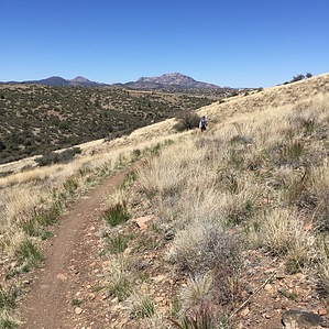
Closing the Loop
by MEWhiteman

 
Overview
The Sundog Trail is part of the Prescott Circle Trail and connects the Badger Mountain Trail at AZ69 to the Peavine Trail. It is an up and down hike over grassy terrain with no shade. It is a smooth, well-graded, easy-to-follow, single-track trail for use by non-motorized travel. While there are some nice views, it passes by car dealerships, a juvenile detention center, and a water treatment plant. This hike may be done as an out and back or a shuttle hike when combined with the Badger Mountain Trail.
Hike
This is described from AZ69 to the Peavine Trailhead. From the north side of the AZ69 culvert where the Badger Mountain Trail ends (N34 33.117 W112 25.019) begin climbing the first of three hills on switchbacks. At 0.41 miles (N34 33.117 W112 25.019) cross a dirt road that appears to come from Prescott Lakes Parkway in the area of York Dodge which is noted on one map as an access point. Continue climbing to reach a high point at about 0.7 miles, then a dip and another high point at about 1.9 miles. At 3.02 miles (N34 33.967 W112 25.941) cross another dirt road, bear right, and begin the third climb. At 3.45 miles the trail levels and crosses a third dirt road. At 4.21 miles (N34 34.028 W112 26.122) cross the paved Sundog Ranch Road and bear right. At 4.3 miles bear right onto an old railroad bed and at 5.07 miles reach the junction of the Peavine Trail and trailhead access and the end of this trail at N34 34.549 W112 25.720.

Check out the Official Route and Triplogs.

Leave No Trace and +Add a Triplog after your hike to support this local community.

2016-04-19 MEWhiteman

    One-Way Notice
    This hike is listed as One-Way.

    When hiking several trails on a single "hike", log it with a generic name that describes the hike. Then link the trails traveled, check out the example.
    WARNING! Hiking and outdoor related sports can be dangerous. Be responsible and prepare for the trip. Study the area you are entering and plan accordingly. Dress for the current and unexpected weather changes. Take plenty of water. Never go alone. Make an itinerary with your plan(s), route(s), destination(s) and expected return time. Give your itinerary to trusted family and/or friends.

     Permit $$
    Various Prescott parks, lakes & trailheads. $3 per car


     Directions
    or
    or
     Road
    Paved - Car Okay

    To Peavine Trailhead
    Mtnlver writes
    If you are taking 17 to highway 69 towards Prescott, turn right at Prescott Lakes Parkway. After about 2 miles, take a right at Sundog Ranch Rd. On your left will be a large parking lot and the trailhead for the Peavine. You will see the the trailhead for Lakeshore Trail at the one mile marker of the Peavine.

    Preston Sands writes
    From the highway 69/highway 89 junction in Prescott, head north about 2.3 miles, and turn right at Prescott Lakes Parkway. After about 0.25 miles, there will be a large parking area on the left. This is the trailhead.

    From PHX (I-10 & AZ-51) 104 mi - about 1 hour 55 mins
    From TUC (Jct 1-10 & Grant) 208 mi - about 3 hours 23 mins
    From FLG (Jct I-17 & I-40) 92 mi - about 1 hours 39 mins
    page created by MEWhiteman on Apr 19 2016 2:33 pm
    helpcorrectionissue

    end of page marker