Route Editor

| Guide | ♦ | 5 Triplogs | 0 Topics |
details | drive | permit | forecast | route |
stats |
photos | triplogs | topics | location |
| 93 | 5 | 0 |
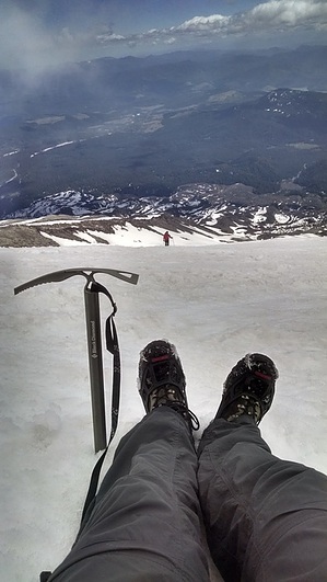
The Worm Flow Route is the winter route for those people who wish to summit Mt. Saint Helens while it is snow covered- typically from November through May. The winter route is a longer hike than the summer route and requires an additional 1,000 feet of elevation gain. Warning Although the Forest Service describes this as a non-technical route to the summit, they highly recommend you carry an ice axe and crampons. When I hiked this route I carried an Ice Axe and wore Micro Spikes on my boots- both came in handy a number of times. In addition to proper gear, avalanche safety and awareness of winter hazards such as cornices and crevasses along this route is extremely important.
From the parking lot, follow the marked trail through the trees and begin heading uphill. The trail starts gradual enough as it winds its way past several marked intersections with snowmobile paths. At 2.3 miles in you will reach a marked intersection with the Loowit Trail that circles Mt. St Helens. Here you will have two options- you can follow a lesser used path up the east side of the ridge along swift creek, or follow the Loowit trail as it drops across the ravine and then climbs to up the west side. Although you can take either path- I STRONGLY encourage you to follow the main path to the west side of the drainage. Having followed the path across the ravine to the west ridge, you will only be on the Loowit Trail for 1/10 of a mile until you reach a sign denoting the turnoff to the Worm Flow climbing route. Turn due north along the Worm Flows route and follow the path as it winds its way along the ridge towards the lower slopes of Mt. Saint Helens. There are a couple of wooden signs posts planted along the route, and previous hikers may have left flagging or cairns to mark the way. Although there are often multiple foot paths in the snow and ice that lead every which way, your best bet is to follow the west ridge line straight up the mountain. When in doubt, I recommend following the path that appears the most worn. It is also helpful to keep an eye on the slopes ahead of you to watch the progress of others as they make their way up or down the mountain in order to gauge the best path. Use your best judgement here and be safe. If you find yourself on a route that just doesn't feel right- either it is becoming too vertical or the footprints have ended, you may want to backtrack or contour along the slopes until you intersect the popular route again. Check out the Official Route and Triplogs. Note This is a difficult hike. Arrive fit and prepared or this could get ugly. Leave No Trace and +Add a Triplog after your hike to support this local community. | |||||||||||||||||||||||||||||||||||||||||||||||||||||||||||||||||||||||||||||||||||||||||