 Route Editor

| Guide | ♦ | 3 Triplogs | 0 Topics |
details | drive | no permit | forecast | map |
stats |
photos | triplogs | topics | location |
| 4 | 3 | 0 |
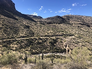
 Most locals are aware of the Apache Trail, with scenic and historic designation, one of America's most beautiful desert roadways. Many adventurous souls search for the next outing, and Dutchman Hunters are seen regularly using the road to gain access to the Superstition and Four Peaks wilderness areas searching for gold. Built from 1903 - 1905, it was built as a service road to get supplies to the Roosevelt Dam site. Originally called the Tonto Wagon Road, the name was later changed to the Apache Trail. Over the last 100 years, the road has been realigned several times due to additional dams being placed downstream. Apache Indian labor was used extensively on the construction of the Tonto Wagon Road. The Roosevelt Dam was constructed from 1905-1910. The Apache Trail is nowadays also known as State Highway 88. For a fun adventure, hike this old deserted section of road. Most locals are aware of the Apache Trail, with scenic and historic designation, one of America's most beautiful desert roadways. Many adventurous souls search for the next outing, and Dutchman Hunters are seen regularly using the road to gain access to the Superstition and Four Peaks wilderness areas searching for gold. Built from 1903 - 1905, it was built as a service road to get supplies to the Roosevelt Dam site. Originally called the Tonto Wagon Road, the name was later changed to the Apache Trail. Over the last 100 years, the road has been realigned several times due to additional dams being placed downstream. Apache Indian labor was used extensively on the construction of the Tonto Wagon Road. The Roosevelt Dam was constructed from 1905-1910. The Apache Trail is nowadays also known as State Highway 88. For a fun adventure, hike this old deserted section of road.Check out the Triplogs. Leave No Trace and +Add a Triplog after your hike to support this local community. One-Way Notice This hike is listed as One-Way. When hiking several trails on a single "hike", log it with a generic name that describes the hike. Then link the trails traveled, check out the example. | ||||||||||||||||||||||||||||||||||||||||||||||||||||||||||||||||||||||||||||||


