 Route Editor

| Guide | ♦ | 10 Triplogs | 1 Topic |
details | drive | no permit | forecast | 🔥 route |
stats |
photos | triplogs | topic | location |
| 149 | 10 | 1 |
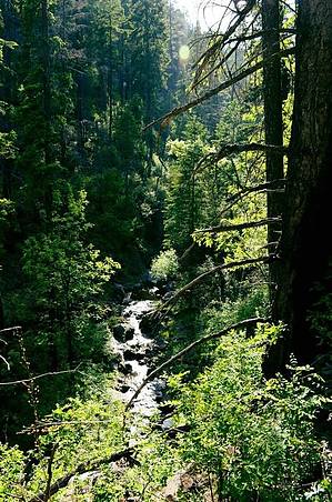
Bring Gaiters by NorthWest  Overview Overview- 9 miles: KP Cienega to Steeple #73 - author went in about 5-6 miles - FS description at the bottom Blue Range History In 1540, the Spanish explorer Francisco Vasquez de Coronado was the first European to travel through the area, and his journal writer described it as a huge trackless wilderness. In 1825 Mountain man James Ohio Pattie visited the Blue Range trapping beaver and marveled at the number of clear running streams, the lush vegetation of the canyons, and the plentiful wildlife. In 1905 Forest Service Employee W.H.B. Kent described the Blue Range as “no discernible mountain range, but rather a chaotic mass of very precipitous hills”.
The Blue Range Primitive Area is the last designated primitive area in the National Forest System. The Blue Range and the presidential recommendation additions together total 199,505 acres and by law are managed the same as congressionally designated wilderness. Located on the edge of the Mogollon Rim and the breaks of the Blue River, this is a land of rugged mountains, steep canyons, and stark ridges that is at the same time remote and accessible through an extensive trail system. Elevations range from 4,500 feet in the southern portion to 9,100 feet along the rim. This rapid change in elevation results in interesting and unique ecological associations. Area The most recent official topographical map of this area that I could find was from 1998 and is available for purchase through Amazon and the National Forest Service website. In 2011 the Wallow Fire heavily damaged this area, and it has not yet been cleared and assessed for trail safety. Be very aware of falling trees and limbs, stump holes, flooding and landslides. There are many standing dead trees that may present a hazard in the wind. This area is also home to a healthy bear population, so bring a canister and be bear aware. Our Journey We headed out from Phoenix to this area early on Friday morning. From Phoenix, it takes about 5 hours to get to the trailhead. The weather when we arrived was overcast, with possible thunderstorms moving through the next day. Luckily, it stayed clear and sunny for us the whole trip. The trail begins in a lovely meadow, and the trailhead is easily accessible by passenger car. We signed in at the trail register and noticed we were one of only three parties for the entire month of May. The party before us had some stock horses with them and stayed three days. The entire three days we were here, we were the only visitors. In late May, daytime temperatures were in the high 70's, and nighttime temps fell to 34 degrees. Hike KP Cienega trail #70 descends from the meadow into a forest and follows KP Creek. We saw many wildflowers blooming and very diverse flora, including salmonberry, thimbleberry, wild strawberries, ferns, and a lot of poison ivy. The forest is slowly starting to reclaim itself from the wildfire of 2011. There are many standing dead trees and massive fallen old growth pines. The trail continues to follow KP Creek to the first junction, about 3 miles in. The junction is signed. We continued South East on Trail #70, which will be a right-hand turn. It is challenging to find a campsite in the area for a tent, hammock campers will be in paradise here as there are ample trees and the terrain is quite steep. We made our first camp at 4.05 miles in. There is a nice flat grass area above the creek with a fire ring. There is more than ample firewood and freshwater from the creek. This is a great spot to turn around and call it a trip. Be very cautious with fire practices, and BE SURE TO DEAD OUT YOUR FIRES. This area is tinder dry and full of fallen wood. If you choose to continue past this point, the trail condition deteriorates rapidly; you are essentially off-trail. Constant scrambling and route finding make for very slow going. The trail will continue to follow KP Creek past the first offshoot ( Blue Lookout #71 ), a second offshoot ( McKittrick #72 ), and an eventual junction with trail #71. Were the trails cleared, you could make a loop up to the Blue Peak lookout, which is what we had hoped to do. Unfortunately, the trail became completely impassable past this junction point, and I strongly advise against going further at this time. HAZ note on the balance of the trail: • bknorby hiked the final 3.2 miles in 2011 on a backpacking trip. Based on the posted route it took 1h 45m. • In 2014, friendofThundergod hiked the 3.2 mi backward not using all of the trail and followed KP Creek in 2 hours. • As of 2016, it is probably getting more difficult. There may be stretches of trail between problem points too. We saw signs from a bear, but it was old. Also saw many fresh elk, coyote, and deer tracks. Also saw eagles, many lizards, and a baby diamondback in the trail. This is a beautiful, barely used wilderness area. Please work hard to keep it this way. Use Leave No Trace practices. In 3 days, we didn't see another single soul or any garbage from previous visitors. TIPS: 1) Bring knee-high gaiters. The trail is excessively overgrown with brambles and branches. 2) Be prepared for many, many fallen trees in the trail. 3) USE SAFE FIRE PRACTICES and check with the fire department to ensure there is no ban in effect. 4) Be weather aware. This area can be prone to flash flooding and sudden storms, which can be very dangerous. Always know your way out. 5) Bring a bear canister. We saw a lot of older bear signs. 6) Carry a topo map and compass or GPS unit. Since the trail follows KP Creek, navigation is not terribly difficult, but the trail is incredibly faint and, at times, entirely gone. 7) Let someone know where you are going and when you plan to be back. Your odds of running into other hikers in case of emergency are very slim here. Apache - Sitgreaves FS Details Listed as 9.4 miles ( really about 9.0 ) In the lush alpine meadow that serves as the setting for KP Trailhead, there is little indication you could start here and find yourself deep in a desert canyon in a reasonably short time. But that's exactly what happens. From KP Cienega, with its stately spruces and emerald grasses, this 9-mile long trail traces the wandering course of the South Fork of KP Creek as it drops toward the Blue. As the trail switchbacks from meadow to stream, upland vegetation gives way to the riparian community of Douglas fir and moisture-loving hardwoods. About 3 miles into the trip, the trail drops sharply into a picturesque canyonscape where the South Fork and the North Fork join to form KP Creek. Each tributary celebrates this get-together with its own ten-foot waterfall. Below the confluence, the canyon deepens as steep cliffs rise from the floor of the gorge. Stream and trail descend together here, between red and gray rock walls, as clear pools alternate with shallow riffles. Crossings become too many to count. At a few points, the trail climbs out of the inner gorge to avoid difficult going, and in the process, offers access to broad views and several prospective campsites. For its last three miles, the KP Trail climbs out of the canyon to offer more great views. Riparian vegetation is replaced by high desert plants, including prickly pear, cholla, yucca, and scrub oak, as the trail leaves behind the sheltered environment of the canyon for dryer, more exposed surroundings. The higher ground also brings broader views of Sawed-Off Mountain as well as KP Canyon. The vista widens to include Bear Mountain and the surrounding ridges of the Blue Range as the trail tops the ridge that separates KP and Steeple Creek Canyons. Views stretching into New Mexico form a panorama as KP Trail ends at its junction with Steeple Creek Trail atop the red, stony mesa. Notes: No mechanized vehicles (including mountain bikes) are permitted in Primitive Area. There are trout big enough to fish for in the pools downstream of the confluence. Trail Log: 0.0 KP Cienega Trailhead. Trail crosses meadow into the timber. 0.9 Trail crosses creek after two switchback descent. 2.7 Trail climbs out of the canyon on the north side. 2.9 Junction with North Fork of KP Trail #93. Two waterfalls are directly downstream. 5.6 Junction with Blue Lookout Trail #71. 6.5 Junction with McKittrick Trail #72. 6.6 Trail crosses creek for the last time as it contours out of drainage bottom to the north. 9.4 Junction with Steeple Trail #73 at a gate. Mud Springs Corral is 1/8 mile away in Steeple Canyon. USGS Maps: Strayhorse, Bear Mountain. Check out the Official Route and Triplogs. Note This is a moderately difficult hike. Leave No Trace and +Add a Triplog after your hike to support this local community. One-Way Notice This hike is listed as One-Way. When hiking several trails on a single "hike", log it with a generic name that describes the hike. Then link the trails traveled, check out the example. | ||||||||||||||||||||||||||||||||||||||||||||||||||||||||||||||||||||||||||||||||||||||||||||||||||||||||||||||||||||||||||||||||||||||||||||||||||||||||||||||||||||||||||||||||||||||||||||||||||||||||||||||


