Route Editor

| Guide | ♦ | 8 Triplogs | 0 Topics |
details | drive | no permit | forecast | map |
stats |
photos | triplogs | topics | location |
| 130 | 8 | 0 |
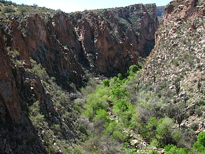
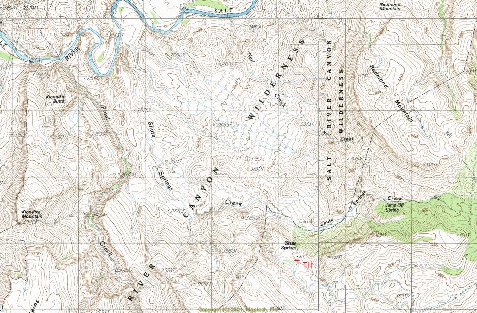
Inner Beauty by ssk44   Overview OverviewPinal Creek Canyon is a remote backcountry destination located in the Salt River Canyon Wilderness within the Tonto National Forest. The topo map name for this area is "Salt River Peak". The Salt River Canyon Wilderness covers about 32,000 acres of wild and remote, rugged desert landscape that rarely sees visitors. If you appreciate solitude and have a genuine love for backcountry adventure, this hike will likely satisfy your appetite. You will be treated to a broad mix of low desert vegetation, lush riparian areas, rugged geology, and diverse wildlife along this hike. This area typically receives consistent rain levels throughout the year, contributing to rich and healthy flora. Warning It is essential for anyone considering this hike to know that the Pinal Creek Canyon segment of this trip involves heavy bushwhacking, constant boulder hopping, and required wading through one stretch of the creek. This hike is not for the easily frustrated. If you're a backcountry junky like me, with an unquenchable thirst for adventure, you will be right at home. Now that the disclaimer has been handled let's get to the fun stuff!!
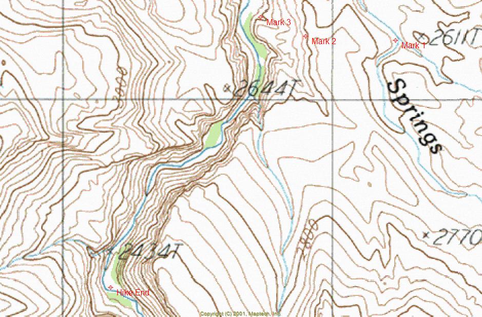
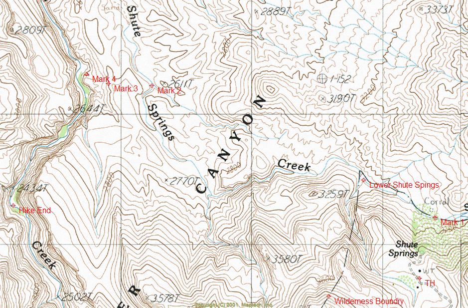
Pinal Creek WQARF Hike The hike as posted starts near the end of FR223. You will find a parking area at the bottom of a hill, within a small valley. From the parking area, walk up a short hill along a jeep road heading to the north and then follow that road down to Shute Springs. From the spring, you will go through a rusty metal gate to the east and follow a fairly obvious pack trail to the bottom of Shute Springs Creek ("Mark 1", Lat. 33 degrees/35'/46.53"/N & Long. 110 degrees/52'/39.72"/W). There is a cairn at the bottom of the trail that is important to note for your return route. The pack trail heading back up to Shute Springs is challenging to see from the sand wash. The sand wash that you are standing in is the route you will follow down to Pinal Creek Canyon. Just a short way down from the pack trail, you will come across the riparian area of Lower Shute Springs at the intersect point of a steep, extremely rugged canyon that heads back up towards the trailhead (Lat. 33 degrees/35'/55.83"/N & 110 degrees/53'/00.93"/W). It is possible to hike up this canyon back to the trailhead, but I can't emphasize enough that it is a very nasty route. Don't say that I didn't warn you. To walk through this riparian area, you will want to stay on the left side. Initially, you will be crossing a mountain of giant boulders that have been violently pushed down the canyon mentioned above. Beyond the boulder segment, you will be walking along a solid rock shelf that follows the trees' edge just above the water. Once you're through the riparian area, things get much easier. For the next 1.75 miles, you will be continuing along the sand wash of Shute Springs Creek. Along this segment, you will find fascinating rock formations and bluffs. After roughly 1.75 miles of easy walking, you will now come up to an unmistakable and significant sand wash on your right that intersects the route that you are following ("Mark 2" Lat. 33 degrees/36'/19.43"/N & Long. 110 degrees/54'/03.97"/W). This location is where you will now head west out of the Shute Springs Creek sand wash to access Pinal Creek Canyon. From here, you will climb up and over a moderate hill to the start of a game trail ("Mark 3" Lat. 33 degrees/36'/19.94"/N & Long. 110 degrees/54'/16.94"/W) that drops down a steep draw into the bottom of Pinal Creek ("Mark 4" 33 degrees/36'/22.22"/N & Long. 110 degrees/54'/23.45"/W). Take a very good mental note of the canyon and overall landscape. Besides the route that I have described, there are no other ways in or out of the canyon. If your reaction is anything like mine, your jaw will drop to the ground when you see the view of what's to come, a stunning hidden riparian canyon with steep and sheer cliffs on both sides. The Pinal Creek segment that I explored is a protected one-mile stretch of lush vegetation that is somewhat opened up when compared to the narrow gorge that is above and below the location. It's hard to believe that this is the same Pinal Creek that only four miles upstream is nothing more than a broad dry sand wash within the Globe city limits. Now for the messy part. If more than two people besides myself have explored this canyon in the last twenty years, I would be surprised. Besides being riddled with large boulders, the route up the canyon was a jungle of tangled old-growth vegetation and flood swept timbers. I was constantly swinging my wood walking staff in front of me to beat open a path through all of the dead branches and limbs along the canyon bottom. If things weren't bad enough, to my shocked amazement, there were beavers along the creek that had dropped many large diameter trees, making navigation of the canyon bottom even worse than it already was. Beavers in the desert? Where is this place again?! For the next messy part, shortly up the canyon, you will come across a mandatory wading segment with sheer rock faces on both sides. There's no way around it. However, the water at its deepest part was only about thirty inches. After coming this far, I was not about to turn around just when things were getting good. While working my way up the canyon, I could not help but be impressed with the severity and height of the intricate cliffs and ledges that towered above the canyon bottom. The creek was a beautiful emerald green color with lovely small waterfalls along the route. After about one mile, you will come across a wide area in the canyon just after a pronounced bend that is a good turnaround point (Lat. 33 degrees/35'/49.54"/N & Long. 110 degrees/54'/45.17"/W). See maps for locations of waypoints described in the text. Summary Hiking into Pinal Creek Canyon is truly an adventure. The feeling of remote isolation and solitude is unmistakable. Just driving to this remote area is an experience in itself. I have a great personal love for the Salt River Canyon Wilderness. This is a unique location that very few people have experienced. The hike is very diverse and has something to offer from start to finish. If you're looking for a unique backcountry hike, you have found it. Count on having it all to yourself if you go. Gate Policy: If a gate is closed upon arrival, leave it closed after you go through. If it is open, leave it open. Leaving a closed gate open may put cattle in danger. Closing an open gate may cut them off from water. Please be respectful, leave gates as found. The exception is signage on the gate directing you otherwise.
Check out the Triplogs. Leave No Trace and +Add a Triplog after your hike to support this local community. | ||||||||||||||||||||||||||||||||||||||||||||||||||||||||||||||||||||||||||||||||||||||||||||||