 Route Editor

| Guide | ♦ | 11 Triplogs | 0 Topics |
details | drive | no permit | forecast | route |
stats |
photos | triplogs | topics | location |
| 202 | 11 | 0 |
No Bugging Out by mt98dew   Overview OverviewThis description is a slight overlap and a continuation of the fantastic description that MWhiteman did on the previous segment of the Black Canyon Trail. This trail is an old sheepherding trail utilized years ago by ranchers. For hiking purposes, it starts from the Carefree Highway (74) down in the valley and then travels north paralleling the I-17 highway and, as of this writing, extends 6 miles north of the 69. Based on an April 6, 2014, article on AZCentral.com, the long-term goal is to have the BCT extend to Williams! How cool would that be? From HAZ's perspective, this would be the 13th segment of this trail. Over the last couple of years, they have created a new trailhead, Big Bug TH, where my hike started. Hike The hike starts from the Big Bug Trailhead, which is on the south side of Highway 69. When you step through the gate, you are on the Black Canyon Trail (BCT). If you make a right, you'll see a rock cairn and a trail that will take you toward Antelope Rd. But to do the newest segment of the BCT, head straight. There will be an old corral to the right and a wire fence to the left. Within 0.1 miles, you'll round a slope and see the tunnel that will take under the freeway. As you go through the tunnel, you'll notice multiple mud-like nests along the upper portions of the tunnel. When I went through the tunnel at 5 am the birds were still emerging from their nests, so the tunnel and the exit were full of birds. It's remarkable how many birds can fit into those tiny, confining nests! After exiting the tunnel, follow the trail that parallels the wash.
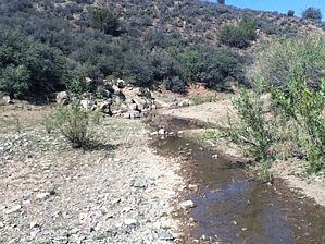
By crossing the road and going about 100 yards down the trail, the trail will bring you to another gate. This gate has a sign posted on it stating "Big Bug Trailhead". Initially, I took this to mean that I would be doing a trail called "Big Bug". Not the case. All the signs thereafter refer to this trail as the BCT, so Big Bug helps identify where you are (approximately) on the BCT. For about the next 2 miles, the trail is easy to follow. It is a clear, well-defined single track with no confusing side trails to mislead. From the gate, it is a nice winding, gradual descent to reach another gate. This should be about 1.7 miles into the hike. 0.3 miles later, you'll cross a sandy wash with BCT signs. From here, the trail remains relatively flat for the next few miles, following the contours of low lying hills heading in a north northeast direction. At 2.5 miles, cross a dirt road that is signed with BCT trail signs. At this point, the trail begins to become a little less well-defined. It is still evident but not as heavily used. It is around the 3.0 mark that cairns start to appear, and you need to be wary of false, misleading game trails. I tried to reinforce some of the cairns for future hikers. During this time, the trail traverses the side of hills, never directly ascending/descending them but using switchbacks to gain and lose elevation. Most cairns appear at these switchbacks to help redirect the direction you are going. (Much of this is a designed trail with hikers and bikers in mind). You'll know you are on the right track if you crest a hill at around the 3.65-mile mark and see a windmill off to the west. From here, the trail heads north and a little west as it descends toward another wash. At 3.75, there is going to be a split in the trail. One heads north, dropping immediately into a wash. The other west, paralleling the wash for a time before crossing it. Follow the track heading west, and you'll soon see a large cairn to reassure you that you are on the correct trail. After crossing the wash, the trail turns north and begins a steady climb. At 4.92, you'll reach a road and a green rancher's gate. Below and to the east, you'll see a large ranch that (I assume) this gate belongs to. A BCT sign and the trail head off to the east side of the road on the gate's other side. I was more interested in mileage than I was in elevation as I recorded information for this description, but I believe this gate crossing was the high point of the hike. By going through the gate, the trail leaves the road and will begin to descend to the valley below. In a short time, the trail will cross another, more rugged road. Head east down the slope, and you'll see the BCT sign and the trail heading off the road. The trail continues to head downward, heading in a northward direction. As you descend, you'll move past the massive ranch to the east and get a better view of its surroundings. At this point, I also started to encounter other trails, most likely created by the livestock of the ranch. At 5.95 miles, the trail crosses a wash with a small flowing stream. At the time of this writing, I easily crossed the streambed without getting wet. The trail heads through a small grove of trees (providing the only natural shade that you'll encounter on the hike) and then start to climb the north bank of the wash. The trail begins to head in a northeastward direction, paralleling a dry wash that feeds into the just departed streambed. Be very wary of bovine-created trails. There are several well-defined trails, better than the BCT, that could very easily mislead. If you don't see a cairn on the track you are following periodically; there is a good chance you have gotten off-trail. A good example was 6.25 miles into the hike. The BCT trail heads out of the wash, but the better-defined bovine trail remains in the wash. From this point, the trail continues to climb among some low lying hills for another 0.75 until it crosses a decent-looking dirt road at the 7.0-mile mark. This was my turnaround point. There are BCT markers on both sides of the road, and the trail continues to the north and east. How much further does the trail continue?? The road where the trail crosses looks drivable, so if one could figure out how to get back there, this might be a good staging point for the next leg of the trail. Not sure what ft road this is, hence the witty name "farm road." Water Sources There are no water sources at this trailhead. Gate Policy: If a gate is closed upon arrival, leave it closed after you go through. If it is open, leave it open. Leaving a closed gate open may put cattle in danger. Closing an open gate may cut them off from water. Please be respectful, leave gates as found. The exception is signage on the gate directing you otherwise. Check out the Official Route and Triplogs. Leave No Trace and +Add a Triplog after your hike to support this local community. One-Way Notice This hike is listed as One-Way. When hiking several trails on a single "hike", log it with a generic name that describes the hike. Then link the trails traveled, check out the example. | ||||||||||||||||||||||||||||||||||||||||||||||||||||||||||||||||||||||||||||||||||||||||||||||||||||||||||||||||||||||||||||||||||||||||||||||||||||||||||||||||||||||||||||||


