 Route Editor

| Guide | 0 Triplogs | 0 Topics |
details | drive | no permit | forecast | route |
stats |
photos | triplogs | topics | location |
| 32 | 0 | 0 |
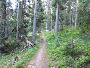
Fantastic backpacking! by withasideofranch This is a great trail with a low (but persistent) incline. I strongly suggest hikers pick up the (as of 2016) wilderness map for ten bucks at the Questa Ranger station before doing this hike. Suggested Backpacking Trip Plan I suggest hiking to the trail junction of horseshoe lake and lost lake, camping, day-hiking to wheeler peak, then leaving the next day. There is plenty of water, flowers, wildlife, and shade on this hike.
The Horseshoe Lake/Lost Lake trail junction sign is hard to spot. Around 4.7 miles you will reach a river crossing. Cross the river and take the trail that goes to the right, NOT the one that follows the riverbank uphill. You should be heading slightly north east after crossing the river, there is an epic campsite on your right (pass it), then the trail reappears and should take you to the junction sign. Water Sources There are plenty. Just make sure you have a good water filter along. Hike See forest service information below. Carson FS Details Trail begins at about 9,600 feet above sea level. Trail 55 to Sawmill Park departs from the East Fork after the first mile. Then the trail crosses the Big Ditch, a 41-mile mining feature constructed in the 1800’s to transport water to the Moreno Valley for mining. The trail follows the East Fork of the Red River for the first 2.5 miles, and then crosses a wooden foot bridge. Then the trail begins climbing moderately through old-growth spruce fir forest. Three more wooden foot bridges are provided for tributary crossings. Eventually the trail intersects Trail 91, the Lost Lake trail at about 11,400 feet above sea level. Trail 91 then ascends about another ½ mile to Horseshoe Lake, below Mount Walter. Most of the trail is moderate and recommended for families. Snow drifts are common at higher elevations through June. -------- The trail starts at the parking area, ¾ of a mile before Ditch Cabin it is an easy hike with a gradual ascent. Just past the Trail #55 junction you will cross the “Big Ditch” which was constructed in 1868 to divert water over 41 miles to mines in Elizabethtown. The trail continues up the East Fork of the Red River for approximately three miles before it turns to the west across a bridge. It climbs for about a mile past a rock slide and a spectacular vista point to the wilderness boundary and the Lost Lake Trail (#91) junction. There are many camping areas along the trail. The campsite at the trail junction is the most popular because of its close proximity to both Lost Lake (approximately one mile) and Horseshoe Lake. Turning south, the trail becomes steeper and somewhat rockier. When you reach Horseshoe Lake elevation 11,950 feet, you experience the beauty of the lake and views from another spectacular vista point. Horseshoe Lake is at timberline; it is often windswept. Please do not damage the ancient bristle cone pine shrubs around the shoreline. Check out the Official Route. Leave No Trace and +Add a Triplog after your hike to support this local community. One-Way Notice This hike is listed as One-Way. When hiking several trails on a single "hike", log it with a generic name that describes the hike. Then link the trails traveled, check out the example. | ||||||||||||||||||||||||||||||||||||||||||||||||||||||||||||||||||||||||||||||||||||||||||||||||


