Route Editor

| Guide | ♦ | 7 Triplogs | 0 Topics |
details | drive | permit | forecast | 🔥 route |
stats |
photos | triplogs | topics | location |
| 51 | 7 | 0 |
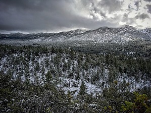
Lives up to its definition.... by Peter_Medal   Maverick Mountain is the 6th highest peak in the Bradshaw Mountain Range. The "Bradshaws" were named for two brothers, Isaac & William Bradshaw. Prior to being named the Bradshaws, were previously known as the Silver Mountain Range. Much of the Bradshaws were occupied by Apache Indians in the 1800s. Upon conclusion of the Civil War, Lincoln commissioned Joseph R. Walker a civil engineer of the Union Army to map out resources of the newly named territorial capital, Prescott. Led by William Bradshaw, the "Walker Party" set out and discovered gold along Lynx Creek and the Hassayampa. Soon thereafter, the Bradshaws filled up with prospectors chasing out the Apaches. Maverick Mountain is the 6th highest peak in the Bradshaw Mountain Range. The "Bradshaws" were named for two brothers, Isaac & William Bradshaw. Prior to being named the Bradshaws, were previously known as the Silver Mountain Range. Much of the Bradshaws were occupied by Apache Indians in the 1800s. Upon conclusion of the Civil War, Lincoln commissioned Joseph R. Walker a civil engineer of the Union Army to map out resources of the newly named territorial capital, Prescott. Led by William Bradshaw, the "Walker Party" set out and discovered gold along Lynx Creek and the Hassayampa. Soon thereafter, the Bradshaws filled up with prospectors chasing out the Apaches.The Bradshaw Range geologic makeup consists of Precambrian schist, granite, and other intrusive rocks. These have been brought to the surface by geologic uplift. In addition, younger tertiary volcanic rocks, like basalt, are outcropped on the hills and mountains of the area. Older Precambrian rocks are underneath.
The Maverick Mountain summit (7443') is located 3 miles south as the crow flies from the Ponderosa Park community; 2 miles south of the Hassayampa River; 2.5 miles south of Wolf Creek Road. Its prominence can be seen looking west from the Senator Highway which is 2.5 miles east of its summit or from the north in the Ponderosa Park community. Maverick shares its southeastern ridgeline with Mount Tritle via Forest Road (more like a jeep trail) 9403C. Maverick is an ideal "add-on" or double summit journey with Mount Tritle. Maverick can also be conjoined with an off-trail journey connecting Wolf Creek Falls and/or the Hassayampa River drainage. The north-south traverse has been flagged with orange tape cairns tied to trees and shrubs. Access to the mountain can be via Forest Road 9403C Check out the Official Route and Triplogs. Leave No Trace and +Add a Triplog after your hike to support this local community. | ||||||||||||||||||||||||||||||||||||||||||||||||||||||||||||||||||||||||||||||||||||||||||||||||||||||||||