Route Editor

| Guide | ♦ | 1 Triplog | 0 Topics |
details | drive | no permit | forecast | 🔥 route |
stats |
photos | triplog | topics | location |
| 15 | 1 | 0 |
The Devil Made Me Do It by JimmyLyding In the early 1970s the Forest Service slated much of the Siskiyou Mountains in California to undergo extensive logging which would require a paved road between the towns of Gasquet (gas-Kay) and Orleans known as the G-O Road or "Go" Road which was almost complete in the early 1980s. The legality of finishing the road wound its way from 2 draft environmental impact statements to the Supreme Court which agreed with the Forest Service in 1988 that finishing the road did not violate Native American religious/cultural rights. However, Congress passed the California Wilderness Act of 1984 which obviated the need to finish the road because the area that was to be logged was included in the new Siskiyou Wilderness. We take the good with the bad.
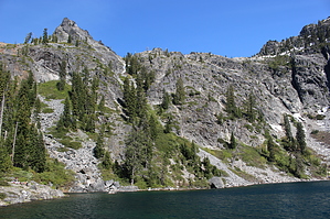
The short 1/4 mile side trip to Buck Lake is worth taking if only to provide a preview of Devils Punchbowl. The lake sits in the base of a deep glacial cirque with spectacular ridges towering 1,000' above. Return to the Doe Flat Trail and continue east to its junction with the Devils Punchbowl Trail a little more than 3.5 miles from the start. This segment is mostly under the cover of a mixed conifer forest, but glimpses of high peaks on the other sides of the Doe Creek and Clear Creek drainages break up the monotony. One note is that the most popular map of the area, National Geographic's Redwood National and State Parks California, USA #218, shows the trail heading north and downhill from Buck Lake to travel along Doe Creek before heading south and uphill to the Devils Punchbowl Trail. The trail has been re-routed to head basically due east along the 4,100' contour because the Forest Service wants to prevent people from spreading Port Orford cedar disease. The disease flourishes in moist areas so the trail now remains high above Doe Creek. The stout uphill climb of the Devils Punchbowl Trail heading south/right from the Doe Creek Trail is definitely memorable. The rough trail climbs 700' in about a half mile up the ridge above the deep box canyon where Devils Punchbowl's drainage joins Clear Creek, and provides the best views of the hike. Preston Peak at 7,300' ASL looms in the east as this hike gets real. Looking at a map leads one to conclude that the rest of the hike to the Devils Punchbowl is relatively straightforward, but that isn't the case. The trail is faint at this point, and has numerous steep ups and downs until it reaches an overgrown boulder field. There are 2 very large trees that have fallen across the trail that are a little tough to get across, but the biggest challenge is the rocky area just below the Devils Punchbowl. Devils Punchbowl is in a glacial cirque. These are formed when a glacier, in this case the Pleistocene-era glacier that flowed down the north side of 6,400' Bear Mountain, expands while pushing geologic debris in front of it to form a depression. This is basically the same process that created Yosemite Valley, but on a much smaller scale. This geologic process created the Devils Punchbowl lake by piling up rocks to form a natural reservoir, and this giant pile of rocks is challenging to overcome. There are parts of the trail that are on high open areas, and other parts that require scrambling through copses of small trees. All that trouble is worth it to reach the Devils Punchbowl, a sky-blue lake resting 1,700' below Bear Mountain. This glacial cirque doesn't so much resemble a bowl as much as it does a pint glass. There are a half-dozen campsites for backpackers here, and it's easily the most-visited spot in the wilderness. It is possible to walk all of the way around the lake, but it would take some effort. Return the way you came. Check out the Official Route and Triplog. Leave No Trace and +Add a Triplog after your hike to support this local community. | ||||||||||||||||||||||||||||||||||||||||||||||||||||||||||||||||||||||||||||||||||||||||||||||||||||||