 Route Editor

| Guide | ♦ | 568 Triplogs | 0 Topics |
details | drive | no permit | forecast | route |
stats |
photos | triplogs | topics | location |
| 63 | 568 | 0 |
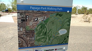
 This loop is a relatively new addition to the trail system in Papago Park. It combines existing and social trails to circle the area northwest of Galvin Parkway and Priest in Phoenix. The trail is six feet wide, constructed mostly of a crushed rock/dirt mix, with a few short sections paved crossing a wash. The trail is signed 5K on posts. It's smooth and has little elevation change. Good for trail running, mountain or even road biking, in addition to hiking. Some of the old par course equipment has been moved near the trail. This loop is a relatively new addition to the trail system in Papago Park. It combines existing and social trails to circle the area northwest of Galvin Parkway and Priest in Phoenix. The trail is six feet wide, constructed mostly of a crushed rock/dirt mix, with a few short sections paved crossing a wash. The trail is signed 5K on posts. It's smooth and has little elevation change. Good for trail running, mountain or even road biking, in addition to hiking. Some of the old par course equipment has been moved near the trail.Check out the Official Route and Triplogs. Leave No Trace and +Add a Triplog after your hike to support this local community. One-Way Notice This hike is listed as One-Way. When hiking several trails on a single "hike", log it with a generic name that describes the hike. Then link the trails traveled, check out the example. | |||||||||||||||||||||||||||||||||||||||||||||||||||||||||||||||||||||||||||||||||||||||||||||||||||||||||||||||||||||||||||||||||||||||||||||||||||||||||||||||||||||||


