This is likely a great time to hike this trail!  Check out "Preferred" months below, keep in mind this is an estimate.
 

Two Spot Trail, AZ

Guide 12 Triplogs Mine 0 0 Topics
 
2.9 of 5 
Fav
Wish
0
details
drive
no permit
forecast
route  
stats
photos
triplogs
topics
location
83 12 0
Statistics
tap icons for details
Difficulty 1 of 5
Route Finding 1 of 5
Distance Loop 2.41 miles
Trailhead Elevation 7,268 feet
Elevation Gain 73 feet
Accumulated Gain 87 feet
Kokopelli Seeds 2.85
 Backpack No
unreported if dogs are allowed
editedit > ops > dogs to adjust
feature photo
Photos Viewed All MineFollowing
Inaugural Calculation on Button Tap!
34  2021-08-03
Arizona Fire Lookouts III
DixieFlyer
4  2020-07-07
Gold Digger Trail
fricknaley
8  2020-05-30
Woody Mountain
The_Eagle
15  2020-04-25
Woody Mountain
chumley
2  2019-04-26
Rogers Trail - Coconino NF
toddak
15  2018-09-28 kingsnake
30  2018-09-09
Gold Digger - Two Spot Trails
tibber
13  2018-07-07
2 Spot-Gold Digger-Woody Mountain
The_Eagle
Page 1,  2
Author
author avatar Guides 11
Routes 2
Photos 3,631
Trips 317 map ( 1,662 miles )
Age 46 Male Gender
Location Mesa, AZ
Associated Areas
list map done
Flagstaff Region
Historical Weather
Trailhead Forecast
Radar Map
Expand Map
Preferred May, Sep, Oct, Jun
Seasons   Spring to Early Autumn
Sun  5:25am - 7:22pm
Official Route
 
8 Alternative
 
 Water
Nearby Area Water
[ View More! ]
Flora  Nearby
Named place  Nearby
Culture  Nearby
Roger's Lake Loop
by cw50must

  Likely In-Season!
Roger's Lake
Rogers Lake, its basin spanning over one mile across, is located in the Upper Verde watershed and is a regionally significant, high-elevation wetland important to numerous wildlife species. In 2010, Coconino County acquired the land of Roger's lake and nearby land at the base of Woody Mountain, and it is now known as the Rogers Lake County Natural Area.Trail
There are two small trailheads with parking areas off Woody Mountain Road for the natural area to access two multi-use trails.

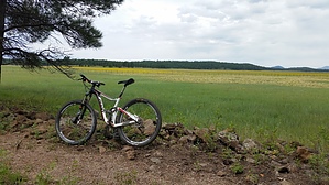
2-Spot Trail is a loop trail that connects both trailheads along the shore of the lake (note lake is dry depending on the time of year). The upper part of the loop runs along the base of Woody Mountain. The trail and both trailheads are well marked. The trail also connects to the longer Gold Digger trail that goes further up Woody Mountain. The trail is multi-use.

The lower part of the loop is supposed to be excellent for wildlife viewing and provides views of the San Francisco Peaks.

Check out the Official Route and Triplogs.

Leave No Trace and +Add a Triplog after your hike to support this local community.

2016-08-24 cw50must
  • PDF Map
    area related
    PDF Map
WARNING! Hiking and outdoor related sports can be dangerous. Be responsible and prepare for the trip. Study the area you are entering and plan accordingly. Dress for the current and unexpected weather changes. Take plenty of water. Never go alone. Make an itinerary with your plan(s), route(s), destination(s) and expected return time. Give your itinerary to trusted family and/or friends.

 Permit $$
None


 Directions
or
or
 Road
FR / Dirt Road / Gravel - Car Okay

To hike
Take Historic Route 66 west from Flagstaff and turn south on Woody Mountain Road. Travel 7.4 miles to the first (or north) trailhead, and travel another 1.1 miles to the second (or south) trailhead (or 8.5 miles from Route 66); stay on Forest Road 231.
page created by cw50must on Aug 24 2016 6:25 am
 90+° 8am - 6pm kills
prehydrate & stay hydrated
helpcorrectionissue

end of page marker