After moving closer to South Mountain, I decided to start heading up this route made popular by JuanJaimeiii and lindaagm. I was kind of shocked that it wasn’t an official description.
Starting from the trailhead at the end of Chandler Blvd, you will cover the first mile or so through winding desert. At right around the 0.6-mile point, you will cross the first wash. Continue onward basically directly across the wash. At the 1 mile point, you encounter the 2nd wash; here is where to follow the wash to the left briefly before climbing out. The trail is super easy to follow, but my first few times out here, I had to give each one a second look.
The journey up the switchbacks to this first peak is probably the toughest physical aspect of this out and back. Once you achieve the ridgeline, you can make really good time. As you make your way up the switchbacks, Goat Hill comes into view.
Descending from the peak, you will follow Pyramid all the way until it turns into National. Here, make sure you veer to the left instead of taking National down to the lookout structure.
Following National is rather simple. The trail is well maintained and easy to get into go mode on. Make sure you don’t dive down Ranger Trail, and you’ll be good to go. As you are chugging along, you’ll pass the remnants of an old mine on your right. This is your signal to start paying attention to a turnoff to the right. Look for this bush and veer right. This is the trail to the top of Goat Hill. It is easy to miss if you have your head down and are just cruising along. I flew by it my first time out there and had to backtrack.
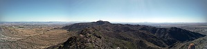
Head up the switchbacks, and you’ll hit the final push of a very slick, scree filled mess. Soak in the views, marvel at the sounds of pew pew pew down below, and head back the way you came.
WARNING! Hiking and outdoor related sports can be dangerous. Be responsible and prepare for the trip. Study the area you are entering and plan accordingly. Dress for the current and unexpected weather changes. Take plenty of water. Never go alone. Make an itinerary with your plan(s), route(s), destination(s) and expected return time. Give your itinerary to trusted family and/or friends.
Permit $$
None
Directions
Road
Paved - Car Okay
To Bursera Trailhead From I-10 going S exit on 202/Pecos Road. Go W on Pecos Road for about 9 miles and turn right on 17th Avenue. Turn left onto Chandler Boulevard and go 0.3 miles to 19th Avenue, turn right(north) with a quick left into the trailhead.
From PHX (I-10 & AZ-51) - 22.6 mi, 28 mins From TUC (Jct 1-10 & Grant) - 104 mi, 1 hour 46 mins From FLG (Jct I-17 & I-40) - 166 mi, 2 hours 48 mins
 Route Editor

 After moving closer to South Mountain, I decided to start heading up this route made popular by JuanJaimeiii and lindaagm. I was kind of shocked that it wasn’t an official description.