 Route Editor

| Guide | ♦ | 1 Triplog | 0 Topics |
details | drive | no permit | forecast | route |
stats |
photos | triplog | topics | location |
| 23 | 1 | 0 |
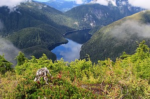
Climb the Clouds by writelots Deer Mountain is a favorite hike for locals of the Ketchikan area, with a trailhead located less than a mile from the heart of downtown. The first mile is the even rather popular with folks just walking off the 3-4 cruise ships which land in Ketchikan daily - eager to stretch their legs and escape the crowds (as many as 9,000 people a day!). Cruise shippers will often get a taxi to drive them the 1.5 miles from the berth to the trailhead, to walk up to the first viewpoint. I suppose this is why there are 1/4 mile markers on the trail indicating how much you've climbed until you reach that first visa. However, even this first mile is not easy by any stretch. It climbs nearly 800' using tight switchbacks and tall steps (usually reinforced with logs). Because its almost always wet in Ketchikan, you're sure to be fighting a little mud, though the tread is reasonably well maintained. At the 1 mile marker, the trees open suffiently to allow views of the sound and the cruise ships at their berths - that is if the fog and mists haven't socked in.
At about 2 miles from the trailhead, the trail enters a clearing and a far superior vista point. If you get here and the clouds are obscuring your view, wait a few minutes - it may change very quickly and open up to the sparkling blue waters below. Don't miss the little muskeg pond just beyond this clearing, its reflective surface and ebony depths are a like a impressionist painting. At 2.5 miles, the trail reaches a junction. Continue straight around to the northeast slope and the Deer Mountain Shelter. The trail system continues on to Blue Lake, Silvis Lake and several more peaks in the area. The Shelters up here are first-come-first-served, but are reportedly way better than trying to keep dry on the boggy ground. If you head right and uphill from the junction you start to climb very steeply up the southern ridge toward the summit of Deer Mountain. Much of the trail here is in the open or in short, snow-stunted trees. At the peak, you can walk a maze of short trails that take you to views off each side of the peak. Particularly striking are the Ketchikan Lakes below (the city's water supply) and the sparkling Tongass Narrows. Weather permitting this is a fantastic spot for lunch, far away from the crowds and shops. This hike is so popular, that an annual event, the "Deer Mountain Challenge", is hosted each year by the local hiking club and includes a champagne toast to those who reach the peak. Next time, I'll bring my own and enjoy the peak like a local! Check out the Official Route and Triplog. Leave No Trace and +Add a Triplog after your hike to support this local community. One-Way Notice This hike is listed as One-Way. When hiking several trails on a single "hike", log it with a generic name that describes the hike. Then link the trails traveled, check out the example. | |||||||||||||||||||||||||||||||||||||||||||||||||||||||||||||||||||||||||||||||||||||||||


