Bonanza Trailhead which accesses Bonanza Peak is little over an hour north from the Vegas Strip. The turn off for the trailhead is off Hwy 95 heading west on Cold Creek Road for 16 miles which is mostly paved except for the last 2 miles. The trailhead is well marked and has large dirt parking area with Bonanza Trailhead sign.
The trail begins gaining elevation immediately with switchbacks from the start numbering 70 or 80 total depending on your count. Trail conditions are excellent with relatively smooth even grade all the way to a saddle on the ridgeline at about 3.75 miles. This section is well forested being on the northeast slope so plenty of shade to rest in the summer months with abundant ponderosa, firs, and some bristlecone.
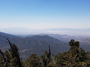
Once on the saddle the trail continues along the ridgeline gaining elevation moderately towards the summit. Less shade on this section with mostly classic bristlecone pine forest. Continuing on the ridgeline the trail reaches a point of several large cairns that have been constructed to mark faint routes to the summit of Bonanza Peak. The trail bypasses the summit about 200 feet below so the summit requires about 1/4 mile of following the faint route. The route is not difficult to follow and once reaching the summit you can see Mt Charleston and good views in all directions. There is a register ammo box on the summit with regular visitors on the weekends. Return back the way you came on the faint route until reaching the trail. The trail continues on towards Mt Charleston and is the divide trail for Mt Charleston Wilderness and offers some backpacking options for those wanting to explore more of the range. For this hike continue back down the same trail to the trailhead.
WARNING! Hiking and outdoor related sports can be dangerous. Be responsible and prepare for the trip. Study the area you are entering and plan accordingly. Dress for the current and unexpected weather changes. Take plenty of water. Never go alone. Make an itinerary with your plan(s), route(s), destination(s) and expected return time. Give your itinerary to trusted family and/or friends.
Permit $$
None
Directions
Road
FR / Dirt Road / Gravel - Car Okay
To hike From Phoenix, AZ
Get on I-10 W
6 min (1.7 mi)
Take US-60 W, US-93, I-40 W, US-93 N and US-95 N to Cold Creek Rd in Clark County
4 h 56 min (331 mi)
Continue on Cold Creek Rd. Drive to Camp Bonanza Coldcreek Rd
30 min (16.1 mi)
Bonanza Trail, North Trailhead
 Route Editor