username
X
password
register
for free!
help
 
  🔥

Superstition Peak 4861, AZ

Guide 2 Triplogs  0 Topics
  3 of 5  
Fav
Wish
1
details
drive
no permit
forecast
🔥
route  
stats
photos
triplogs
topics
location
10 2 0
Statistics
tap row or icons for details
Difficulty 4.5 of 5
Route Finding 4 of 5
Distance One Way 2.7 miles
Trailhead Elevation 2,082 feet
Elevation Gain 2,700 feet
Accumulated Gain 2,793 feet
Avg Time One Way 1-3 hours
Kokopelli Seeds 12.01
 Interest Off-Trail Hiking, Seasonal Waterfall & Peak
 Backpack Possible - Not Popular
unreported if dogs are allowed
editedit > ops > dogs to adjust
feature photo
Photos Viewed All MineFollowing
2  2024-02-17 mt98dew
1  2023-03-29 pseudalpine
3  2017-01-08 syoung
4  2016-09-17 syoung
Author
author avatar Guides 6
Routes 23
Photos 1,125
Trips 593 map ( 3,813 miles )
Age 46 Male Gender
Location Mesa, AZ
Associated Areas
list map done
Phoenix Region
Historical Weather
Trailhead Forecast
Radar Map
Expand Map
Preferred Feb, Nov, Mar, Jan → Early
Seasons   ALL
Sun  6:02am - 6:47pm
Official Route & 3 Rts
 
0 Alternative
 
Historic Fire Perimetersacres
🔥 2024 Siphon Fire35.9 mi*
🔥 2020 Superstition Fire9.6k
🔥 View (All) - over Official Route 🔥
*perimeter length in miles


Helm of Shiprock
by syoung

 
Superstition Peak 4861 - The Helm of Shiprock

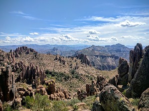
This peak looms to the northeast of Flatiron. It is craggly and full of hoodoos. It is a bit of a scramble to reach the top, but the views are pretty incredible; a top-down view of Flatiron, Peak 5057, Weaver’s Needle, Picketpost, Four Peaks, and the Superstition Wilderness. This is now my favorite scenic location in the Superstitions.


To get up to this peak first you must travel up towards Flatiron. Whatever route you prefer is fine as long as you make it to the second saddle. When you reach this saddle, if you go straight and to the left, you will head to 5024; if you go right, you will proceed to Flatiron, but you will head up in a direction a little bit between these two.
remove free decal offer
The route is entirely off-trail, with scrambling and bouldering involved. There are numerous routes to reach the peak, and it is a real-life choose your own adventure novel, so pick the route that you feel most comfortable about.

2016-09-17 syoung
  • 2018 Lost Dutchman SP Info
    area related
    2018 Lost Dutchman SP Info
  • 2018 Lost Dutchman SP Map
    area related
    2018 Lost Dutchman SP Map


Check out the Official Route and Triplogs.

Note
This is a more difficult hike. It would be unwise to attempt this without prior experience hiking.
Leave No Trace and +Add a Triplog after your hike to support this local community.

One-Way Notice
This hike is listed as One-Way.

When hiking several trails on a single "hike", log it with a generic name that describes the hike. Then link the trails traveled, check out the example.
WARNING! Hiking and outdoor related sports can be dangerous. Be responsible and prepare for the trip. Study the area you are entering and plan accordingly. Dress for the current and unexpected weather changes. Take plenty of water. Never go alone. Make an itinerary with your plan(s), route(s), destination(s) and expected return time. Give your itinerary to trusted family and/or friends.

 Permit $$
None


 Directions
or
 Road
Paved - Car Okay

To Mining Camp Trailhead
2011-10-03 FREE access via Mining Camp
Drive to Mining Camp
General area access map

From PHX (I-10 & AZ-51) - 48 min (37.3 miles)
From TUC (Jct 1-10 & Grant) - 1 h 51 min (110 miles)
From FLG (Jct I-17 & I-40) - 2 h 44 min (183 miles)
page created by syoung on Sep 17 2016 3:44 pm
 90+° 8am - 6pm kills
helpcorrectionissue

end of page marker