Overview
This is a challenging hike in the McDowell Sonoran Preserve in Scottsdale and worth the effort. There are great views along the way and at the top, and the area around Tom's Thumb itself is like a giant rock garden. Just peruse some of the photos from this hike and the original Tom's Thumb hike on this site. The hike from this side is quite a bit longer and more strenuous than that from the north, but the trail is well marked and easy to follow. The hike starts at the Gateway Access Area on Thompson Peak Parkway and makes use of several trails up to Tom's Thumb and returning over Windgate Pass. It can also be done as an out and back or extended making use of other trails in the McDowell Sonoran Preserve.
Hike
Begin on the access trail crossing the bridge behind the building at the Gateway Access area at N33 38.962 W111 51.496. In a short distance, you pass through a crossroad area with signs and a wall. Just continue straight. At 0.4 miles from the start (N33 38.959 W111 51.125), you come to the Gateway Loop Trail. Turn left here. At 0.6 miles you come to the Horseshoe Trail; continue straight on the Gateway Loop. At 1.6 miles (N33 39.549 W111 50.367) you come to an intersection with the Windgate Pass Trail (WPT). Go straightest onto the Windgate Pass Trail. At 2.2 miles the Desert Park Trail comes in from the left; continue on the WPT. At 2.6 miles (N33 40.023 W111 49.777) the Tom's Thumb Trail comes in from the left; turn left here onto the Tom's Thumb Trail (TTT). At 3.0 miles an unmarked trail comes in from the left. Bear right to stay on the TTT. At 3.3 miles (N33 40.340 W111 49.417) you cross a wash and runoff from a spring.
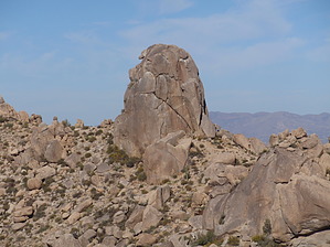
From here the climb gets steeper. There are numerous switchbacks and better and better views to the south and west. At 5.1 miles (N33 40.689 W111 48.564) a spur trail leads to the right to The Lookout. At this point, you might consider passing this by as you've climbed about 2,400 feet AEG, but think twice. The hike to The Lookout adds 1.0 miles to the hike and about 300 feet of ascent, but the views are nice; almost 360 degrees. You can see where you've been and where you are going. The mileages from hereon include the spur. Continuing on the TTT from the spur trail the trail to Tom's Thumb itself comes in from the left at 6.4 miles (N33 40.774 W111 48.529). The sign says 0.2 miles to Tom's Thumb, but I had been there on several occasions so passed it by. At 6.7 miles (N33 40.750 W111 48.240) you come to the intersection with the East End Trail. Turn right here onto the East End Trail. This goes sharply down the east side of the mountain providing great views to the east. Watch the loose gravel and the sharp dropoffs at the edge of the trail.
At about 8.0 miles (N33 39.892 W111 48.008) you intersect with the Windmill Trial. Turn right following the sign to the Windgate Pass Trail at 8.2 miles (N33 39.890 W111 48.089). Continue on the WPT crossing the pass at 9.1 miles and back to the intersection with the Tom's Thumb Trail where you began the loop portion of this hike. Stay on the WPT here and return to the Gateway Access area the same way you came hours before.
WARNING! Hiking and outdoor related sports can be dangerous. Be responsible and prepare for the trip. Study the area you are entering and plan accordingly. Dress for the current and unexpected weather changes. Take plenty of water. Never go alone. Make an itinerary with your plan(s), route(s), destination(s) and expected return time. Give your itinerary to trusted family and/or friends.
Permit $$
None
Directions
Road
Paved - Car Okay
To Gateway Trailhead Take the 101 to the Princess Drive/Pima Road exit. Go north on Pima Road to Union Hills Drive. Turn right (east) on Union Hills Drive to Thompson Peak Parkway. Turn right on Thompson Peak Parkway and head south about 1/2 mile to the Gateway Visitor Center on the left. There's plenty of parking and nice facilities here.
or
Take 101 to Bell Road exit (by way of either FLW Blvd exit 39 arriving from the south or Pima/Princess exit 36 arriving from the north). Go East on Bell road 1.7 miles and turn left onto Thompson Peak Parkway. The Gateway is 0.7 miles on the right. (18333 N. Thompson Peak Parkway)
From PHX (I-10 & AZ-51) - 28.4 mi, 36 mins From TUC (Jct 1-10 & Grant) - 126 mi, 2 hours 6 mins From FLG (Jct I-17 & I-40) - 141 mi, 2 hours 33 mins
 Route Editor

 Overview