Lost Mine is not a destination trail, but more of a way to quickly get to National Trail from the Bursera Trailhead or make a loop hike with many other trails at the southwest end of South Mountain.
Getting to the start of the trail is the only route-finding challenge--and an easy one at that. Starting from the Bursera Trailhead, take Pyramid trail about 7/10th of a mile to a fork in the trail. There is a metal trail marker (no mileage listed on it) pointing Pyramid off to the right; you will take the left fork here, heading north-northwest. After less than a quarter-mile, this trail reaches an old jeep road. Take a left on the jeep road, continuing to head northwest. The trail quickly drops down into a wash. It will follow the south side of the wash for about 200 feet, then head toward the north side of the wash. Start paying attention here; after following the north side of the wash for about 100 feet, you will reach a large palo verde tree. Immediately behind this palo verde, a trail leads directly up the side of the wash to the north. This is the beginning of Lost Mine Trail.
Take the trail up out of the wash and generally follow it north. The hill you will be climbing is ahead of you to the right, and there will be another wash to your left. As you take the trail north, there will be a faint fork. You will head right and start to climb uphill, getting steeper as you go. If, for some reason, you end up at the wash on the left, you missed the fork and need to backtrack a short distance.
The trail heads northeast steeply up the hill. The trail is narrow, but easy to follow. As you climb, to your left, you'll see the remnants of some of the larger mines in the area on the hillside opposite you. You'll reach a sort of small saddle. The trail turns to the north and isn't quite as steep for a while. Enjoy this chance to catch your breath. It will get steeper again. You can clearly see Pyramid trail about 1/4 mile to your east.
After heading north for a while, the trail gets rockier and starts to curve up the hillside. This my favorite section of the trail, as the views to the south and over Ahwatukee are lovely. At the top, you reach the Lost Ranch Mine trail. From here, you can take a left and head immediately back downhill on Lost Ranch Mine, or turn right and reach National Trail in about 1/4 mile, giving you several more extended loop options.
When hiking several trails on a single "hike", log it with a generic name that describes the hike. Then link the trails traveled, check out the example.
WARNING! Hiking and outdoor related sports can be dangerous. Be responsible and prepare for the trip. Study the area you are entering and plan accordingly. Dress for the current and unexpected weather changes. Take plenty of water. Never go alone. Make an itinerary with your plan(s), route(s), destination(s) and expected return time. Give your itinerary to trusted family and/or friends.
 Route Editor

 Lost Mine is not a destination trail, but more of a way to quickly get to National Trail from the Bursera Trailhead or make a loop hike with many other trails at the southwest end of South Mountain.
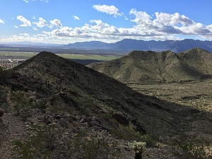


