Route Editor

| Guide | ♦ | 14 Triplogs | 0 Topics |
details | drive | permit | forecast | route |
stats |
photos | triplogs | topics | location |
| 95 | 14 | 0 |
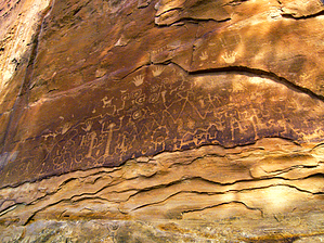
escape the crowds at me-ve by PrestonSands  Mesa Verde National Park's Petroglyph Point Trail loops around the west side of Chapin Mesa, past the Park's largest known petroglyph panel, below Petroglyph Point (also known as Pictograph Point). The trail also introduces one to the area's geology and native plants, and how they were used by the Ancestral Puebloans of Mesa Verde. Hikers are required to sign in at the Chapin Mesa Museum, or at the trail information box, located where the trail splits off from the Spruce Tree House trail. Trail guides explaining the numbered posts found along the Petroglyph Point Trail can be borrowed or purchased from this box as well.
From the south side of the Chapin Mesa Museum, follow the signs for Spruce Tree House. An asphalt walkway leads into the canyon bottom below the museum, where the Petroglyph Point and Spruce Canyon Trails diverge near the exit sign for the Spruce Tree House loop path. You will want to take the short loop through Spruce Tree House, one of Mesa Verde's most impressive cliff dwellings if you have not already done so. Turning onto the shared path of the Petroglyph Point and Spruce Canyon Trails, the hike heads down the shady canyon floor for a short distance, before the two trails go their separate ways. Go left on the Petroglyph Point Trail, which begins an undulating climb along the side of Chapin Mesa. The Petroglyph Point Trail follows a series of sandstone benches below the mesa's cliff edge, weaving past several alcoves and overhangs. Near post number 10, a backward glance reveals a small ruin above the trail, tucked into one of these alcoves. A more accessible alcove near post 18 contains several low walls. About one and a half miles from the trailhead, at post 24, the trail arrives at the petroglyph panel. Carved into the Cretaceous Cliff House Sandstone, just above the trail, is an assortment of interesting shapes and animal representations covering an area approximately fifteen feet wide by six feet tall. From the petroglyph panel, the trail makes an abrupt scramble through a weak spot in the cliffs, to the top of the mesa, one hundred feet above. Once on top, the Petroglyph Point Trail turns north to follow the west edge of Chapin Mesa. Openings in the pinyon-juniper forest present views to the west of canyons that cut into the broad expanse of Mesa Verde. Near the head of the canyon that lies to the west, Chapin Mesa Museum comes into view again, and the trail crosses a concrete dam above a dry waterfall. Once across, one can look down at Spruce Tree House in the canyon below, and the trail rejoins the paved walkway to Spruce Tree House, just below the museum. Check out the Official Route and Triplogs. Leave No Trace and +Add a Triplog after your hike to support this local community. | |||||||||||||||||||||||||||||||||||||||||||||||||||||||||||||||||||||||||||||||||||||||||||||||||||||||||||||||||||||||||||||||||||||||||||||||||||||||||||||||||||||||||||||||||||||||||||