Route Editor

| Guide | ♦ | 7 Triplogs | 0 Topics |
details | drive | no permit | forecast | route |
stats |
photos | triplogs | topics | location |
| 25 | 7 | 0 |
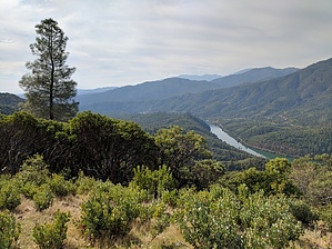
Spiraling to the Top by lojones5  This trail branches off from the middle of the Flanagan trail which is accessed from the trailhead at Flanagan road. The Chamise Peak trail offers great views of the Sacramento River below, as well as the many mountains and trees surrounding the area. The trail lends itself well to bikers as well, and follows a steady slope to the peak. Warning You will be exposed to the sun throughout much of the hike, so wear sunscreen and drink water. The trail is probably more enjoyable in the Fall during cooler temperatures.
The trail is well marked and easy to follow. Start at the Flanagan trailhead and hike Flanagan Trail until reaching the link to the Chamise Peak Trail. There is plenty of signage as well as a bench where the trails meet. The last half mile or so spirals around before reaching the top and provides views from every side of the peak during the hike up. From the peak look for Shasta Dam, Shasta Lake, Mount Shasta, the City of Shasta Lake, Keswick Reservoir, Trinity Alps, and even Mt Lassen. Water Sources No water sources on this trail
Check out the Official Route and Triplogs. Leave No Trace and +Add a Triplog after your hike to support this local community. | |||||||||||||||||||||||||||||||||||||||||||||||||||||||||||||||||||||||||||