username
X
password
register
for free!
help


Flying V Canyon, AZ

Guide 3 Triplogs  0 Topics
  5 of 5  
Fav
Wish
2
details
drive
permit
forecast
map
stats
photos
triplogs
topics
location
25 3 0
Canyons are inherently risky. Flash floods occur without notice on sunny days. Technical skills & surrounding topography knowledge required yet does not eliminate risk.
Statistics
tap row or icons for details
Distance One Way 3.5 miles
Trailhead Elevation 4,922 feet
 Interest Off-Trail Hiking, Seasonal Waterfall, Perennial Waterfall, Seasonal Creek & Perennial Creek
unreported if dogs are allowed
editedit > ops > dogs to adjust
feature photo
Photos Viewed All MineFollowing
2  2012-06-16
Salt River Canyon - Upper Gorge
ssk44
23  2009-04-26 ssk44
11  2009-04-26
Salt River Kayaking
ssk44
Author
author avatar Guides 16,843
Routes 17,472
Photos 24
Trips 1 map ( 6 miles )
Age 28 Male Gender
Location HAZ, TrailDEX
Historical Weather
Trailhead Forecast
Expand Map
Preferred Oct, Nov, Mar, Apr
Sun  5:58am - 6:42pm
0 Route
 
0 Alternative


remove free decal offer

 
Guide Needed
Publish Full Detail Guide


Use +Add above to share photos and triplogs
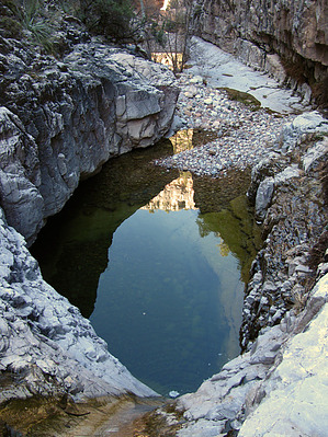
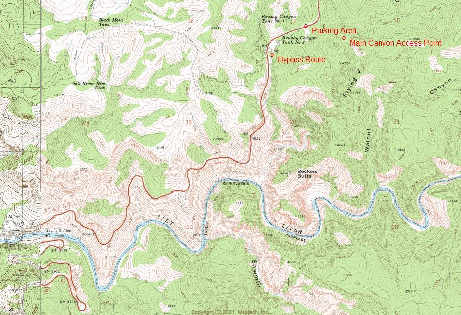
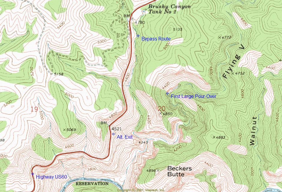
Overview: Canyoneering route down a beautiful side canyon of the more well known Salt River Canyon. Hike ends at the Salt River.


  • guide related image guide related image
    guide related


Check out the Triplogs.
Leave No Trace and +Add a Triplog after your canyon trip to support this local community.
WARNING! Hiking and outdoor related sports can be dangerous. Be responsible and prepare for the trip. Study the area you are entering and plan accordingly. Dress for the current and unexpected weather changes. Take plenty of water. Never go alone. Make an itinerary with your plan(s), route(s), destination(s) and expected return time. Give your itinerary to trusted family and/or friends.

 Permit $$
• Some areas are closed to access from Labor Day to April 1st, read about it in the link provided below.
• Permits, closures and regulations at White Mountain Apache Tribe < Cibecue, Black River, Salt River, etc.
Sunrise Park Resort


 Directions
or
 Road
Paved - Car Okay

To canyon trip
From Mesa, take US60 to Globe. From Globe, take US60 northeast towards Show Low. Drive through Salt River Canyon and park at a large parking area (highway pull-off) at a saddle just after exiting the canyon. The north side of Salt River Canyon is located on the White Mountain Apache Indian Reservation.

(Canyon access is southeast of trailhead, following the left side of ridge.)
page created by ssk44 on Apr 22 2009 4:49 pm
 90+° 8am - 6pm kills
helpcorrectionissue

end of page marker