Route Editor

| Guide | ♦ | 6 Triplogs | 0 Topics |
details | drive | permit | forecast | route |
stats |
photos | triplogs | topics | location |
| 45 | 6 | 0 |
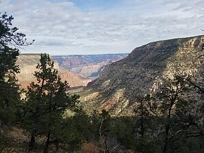
smile after smile by BiFrost  This hike begins at the locked gate that marks the trailhead with several parking spots before the gate. The trail follows an old road through pinyon pine and juniper for about 3/4 mile until it reaches the Waldron Trail sign. The actual trail starts here and continues down canyon for another 3/4 of a mile past Horsethief Tank and eventually leaves the drainage onto a saddle. From the saddle, the trail drops rapidly into Hermit Basin over the next mile about 800 feet through a series of tight switchbacks. At about 3 miles the trail reaches the Hermit Trail junction which is the end of Waldron Trail. This hike begins at the locked gate that marks the trailhead with several parking spots before the gate. The trail follows an old road through pinyon pine and juniper for about 3/4 mile until it reaches the Waldron Trail sign. The actual trail starts here and continues down canyon for another 3/4 of a mile past Horsethief Tank and eventually leaves the drainage onto a saddle. From the saddle, the trail drops rapidly into Hermit Basin over the next mile about 800 feet through a series of tight switchbacks. At about 3 miles the trail reaches the Hermit Trail junction which is the end of Waldron Trail.Continuing on another 1/4 mile Hermit Trail reaches Drippings Springs Trail junction that will traverse over to the spring. It's about 2 miles over to the spring as the trail weaves in and out of side drainages. Just before the spring is the Boucher Trail junction then continue another 1/2 mile or so to Dripping Springs. The junctions are hard to miss as each one is marked by very large signs.
From here the trail turns back into an old two-track road and is fairly easy to follow. Very flat on top compared to the past 7 miles with easy walking through the forest. Near the beginning of the rim walk, there is an old corral along the road. This two-track road continues for another mile until it reaches the NPS boundary road. Just before reaching the NPS road, there is a Dripping Springs sign on the ground but it's easy to miss. Following the NPS road, it's super highway and goes by quickly for another 0.8 miles to the next road turnoff. At about the 9.5-mile mark turn left off the NPS road onto another two-track. It's not marked other than spotting the old road but it shows on the topo map only 1/2 from where the Waldron Trail sign is marked. Once arriving back at the Waldron Trail sign this closes the loop and heads back on the same road to the locked gate. Gate Policy: If a gate is closed upon arrival, leave it closed after you go through. If it is open, leave it open. Leaving a closed gate open may put cattle in danger. Closing an open gate may cut them off from water. Please be respectful, leave gates as found. The exception is signage on the gate directing you otherwise. Check out the Official Route and Triplogs. Leave No Trace and +Add a Triplog after your hike to support this local community. | ||||||||||||||||||||||||||||||||||||||||||||||||||||||||||||||||||||||||||||||||||