Route Editor

| Guide | ♦ | 4 Triplogs | 0 Topics |
details | drive | no permit | forecast | map |
stats |
photos | triplogs | topics | location |
| 27 | 4 | 0 |
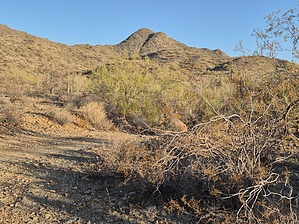
Syenite-mare on Elm Street by DixieFlyer  Overview OverviewThe Syenite 2 Benchmark is atop an unnamed peak that is in the Hieroglyphic Mountains and is the high point of the city of Peoria, a suburb of Phoenix. The peak has a spot elevation of 2,783 feet and a clean prominence of 623 feet. Hike There is no trail on this hike, but you will likely be able to take advantage of some forest roads and/or mountain bike paths to limit the amount of off-trail hiking that you have to do. The entirety of the hike as described in this guide is on BLM land.
There are two routes that one could take to the summit from the "default" trailhead: 1) a ridgeline south of the peak, or 2) a ridgeline east of the peak. From the trailhead, the south ridgeline is a more direct route but it gets steep and has some rock outcroppings that you'd to scramble over or around. The east ridgeline has a more gentle gradient and it has much more favorable terrain. However, it is a longer route to get there from the trailhead unless you are able to drive further to the east. It is a good idea to check triplogs and see what routes others may have chosen. The stats listed for this hike are based on hiking from the "default" trailhead and going up the steep south ridge. For many hikers it would be worth adding a little distance and elevation gain by hiking to the northeast from the trailhead and going up the more gentle east ridge instead. Even better is if you are able to drive further to the northeast to begin the hike, which would put you in a much closer position to access the east ridge. No matter which route you take, you'll be hiking through some desert vegetation. Fortunately, the vegetation is not very dense and while you'll need to avoid some occasional thorny plants to circumvent, this really should not be called bushwhacking. You will likely have to drop into and back out of 2-3 steep washes along the way, but if you look around getting in and back out is not too onerous. The peak will be in view almost the whole way, which will help your navigation. There are nice 360-degree views at the summit, so there is a good payoff for your efforts! Check out the Triplogs. Leave No Trace and +Add a Triplog after your hike to support this local community. | |||||||||||||||||||||||||||||||||||||||||||||||||||||||||||||||||||||||||||||||||||