Helipad Trail is a short side trip off Desert Classic to an old helipad overlooking the Ahwatukee Foothills. The trail seems to receive a lot of mountain bike use but is also a pleasant stroll on foot.
The trail starts on Desert Classic at trail post DC6.42 (formerly post 54) and heads south. You will drop down into a large wash, cross it, then head uphill toward a saddle. At the saddle, the trail forks (I believe the trail branching to the left will take you down to Ray Rd near 30th St), and you will take a right (west) and continue uphill, working your way up to the ridgeline. At the west end of the ridge sits the old helipad.
Enjoy the views, then either return the way you came or come down Goat Trail, which heads north to Desert Classic just a few hundred feet from the end of the Helipad trail. Goat Trail is about 0.35 miles in length and connects back to Desert Classic at trail post DC7.22
When hiking several trails on a single "hike", log it with a generic name that describes the hike. Then link the trails traveled, check out the example.
WARNING! Hiking and outdoor related sports can be dangerous. Be responsible and prepare for the trip. Study the area you are entering and plan accordingly. Dress for the current and unexpected weather changes. Take plenty of water. Never go alone. Make an itinerary with your plan(s), route(s), destination(s) and expected return time. Give your itinerary to trusted family and/or friends.
Permit $$
None
Directions
Road
Paved - Car Okay
To Telegraph Pass Trailhead From I-10 take Chandler Boulevard 4.8mi west to Desert Foothills Parkway. Turn right and follow 1.3mi. The parkway curves west. It's easy to find.
Quicker: Alternate route: From I-10 and the Loop 202 take Pecos Road west, which is a westward extension of the 202. Go 5 miles to Desert Foothills Parkway. Take a right going north on DFP for 2.5 miles to the trailhead on the right side of the road.
From PHX (I-10 & AZ-51) 19.4 mi - about 30 mins From TUC (Jct 1-10 & Grant) 102 mi - about 1 hour 36 mins From FLG (Jct I-17 & I-40) 163 mi - about 2 hours 37 mins
 Route Editor

 Helipad Trail is a short side trip off Desert Classic to an old helipad overlooking the Ahwatukee Foothills. The trail seems to receive a lot of mountain bike use but is also a pleasant stroll on foot.
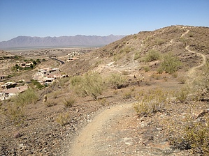


