Route Editor

| Guide | ♦ | 1 Triplog | 0 Topics |
details | drive | no permit | forecast | route |
stats |
photos | triplog | topics | location |
| 3 | 1 | 0 |
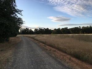
A stroll through nature by lojones5  The Churn Creek Trails are a quick an easy way to walk through some nature without straying far from the neighborhood. The trails are open from daylight to dusk. Warning While dogs and bikes are welcome on the Churn Creek trails, they are prohibited on the connecting Lema Ranch trails which are property of the McConnell Foundation who kindly allow hikers to freely walk through their trails.
The hike consists of gravel trails, and passes an open field before becoming more shaded by large oak trees. The paths are generally quiet, although you may see people from the neighborhood walking their dogs on the trail since the trail can be accessed from several locations from the surrounding neighborhood. There is a small park/playground near the south end of the trails called Minder Park, which can be a great place to walk to with a family. There are many side trails in the area that all eventually lead back to one another, so you can take a different route with each visit. Check out the Official Route and Triplog. Leave No Trace and +Add a Triplog after your hike to support this local community. | ||||||||||||||||||||||||||||||||||||||||||||||||||||||||||||||||||||||||||||||