 Route Editor

| Guide | ♦ | 5 Triplogs | 0 Topics |
details | drive | no permit | forecast | route |
stats |
photos | triplogs | topics | location |
| 52 | 5 | 0 |
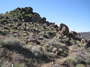
Mohave County Gold by AZLOT69   Overview OverviewThe Badger Trail is part of the Cerbat Foothills Recreation Area, a joint program with BLM and the City of Kingman. The trail is open to hikers, horses, and mountain bikes. It is relatively easy to miss the trailhead as traffic is going at least 65 on a beeline to Las Vegas. It is a nice break on the way to or from Las Vegas to unwind. The trail is a steady, moderate grade up to a saddle offering views in all directions. There is virtually no shade available on this hike. Plan accordingly. Spring offers the most perks as there are many flowering desert plants. Hike The well-defined trail starts among nice stands of ocotillo and yucca. It begins its climb immediately. On your first visit, if you are like me, you will scan the horizon to see if you can anticipate the trail's path. Usually, I'm pretty good at picking it up, but I misjudged this one. Even when it took an obvious turn away from where I thought it was headed, I still figured it would switchback, which it never did. It adds a little intrigue to the outing. Shortly after the start, you will come to a debris field of spectacular samples of very white quartz. To the left and high above the trail, you can see the remains of an old mine. I was also confident that the trail would go to the vicinity of that old mine, but I was wrong again. Plan on making the mine a side trip up a wash littered with quartz marking the way.
Check out the Official Route and Triplogs. Leave No Trace and +Add a Triplog after your hike to support this local community. One-Way Notice This hike is listed as One-Way. When hiking several trails on a single "hike", log it with a generic name that describes the hike. Then link the trails traveled, check out the example. | |||||||||||||||||||||||||||||||||||||||||||||||||||||||||||||||||||||||||||||||||||||


