 Route Editor

| Guide | ♦ | 303 Triplogs | 3 Topics |
details | drive | no permit | forecast | route |
stats |
photos | triplogs | topics | location |
| 393 | 303 | 3 |
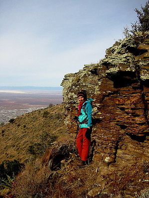
Classic A by imike The hike begins right in town at an unmarked drainage and proceeds up to the classic "A" marked in white painted rocks (Alamogordo!), and proceeds upward slowly move to the south side of the Peak. The trail crests at an old metal water tank then moves onto a saddle at 3.6 miles up and to the right (south) of Ortega Peak. At this saddle, T119 continues on for another 1.6 miles, but Ortega Peak is accessed by leaving the trail and working your way up the final few hundred feet. The route is rocky, steep and shrub/cacti covered, but not too great of a challenge. Your efforts will be rewarded with a 360 degree view of the distant Sierra Blanca Peak, San Andreas Mts, Organ Mountains and the Tularosa Basin/White Sands area. You also are overlooking most of Alamogordo.
Note: The Sacramento Mountains are subject to seasonal closure due to wildfire danger... typically in the months of May and June. Check out the Official Route and Triplogs. Leave No Trace and +Add a Triplog after your hike to support this local community. One-Way Notice This hike is listed as One-Way. When hiking several trails on a single "hike", log it with a generic name that describes the hike. Then link the trails traveled, check out the example. | ||||||||||||||||||||||||||||||||||||||||||||||||||||||||||||||||||||||||||||||||||||||||||||||||||||||||||||||||||||||||||||||||||||||||||||||||||||||||||||||||||||||||||||||||||||||||||


